
Today the broad expanse of the Great Plains, which forms the central part of North America, is a vast area of farms, prairies, and deserts. Here, immense herds of buffalo once roamed and wild mustangs galloped. However, the land did not always look like a swelling sea of grass. During the prehistoric past this was, quite literally, a sea. In fact, the central part of North America has been inundated underwater at several points throughout prehistory.
For example, during the middle to late Jurassic Period, most of central North America was underneath a shallow body of saltwater called the “Sundance Sea”. Here lived oysters, fish, hybodont sharks, belemnites, and at least three species of marine reptiles. When this sea was at its fullest-size about 165-160 million years ago, North America was shaped like a U, with the sea in the middle. However, as sea levels dropped and as tectonic forces pushed the North American landmass upwards above sea level, the Sundance Sea gradually shrank until it completely disappeared by the end of the Jurassic Period.
Many people with knowledge of paleontology will recall that later, during the middle to late Cretaceous Period, central North America lay underneath another body of saltwater called the “Western Interior Sea”. This was much larger and deeper than the earlier Sundance Sea, and it completely split North America in half. Here lived famous marine creatures such as the giant plesiosaur Elasmosaurus, the giant mosasaur Tylosaurus, the enormous sea turtle Archelon, and several species of huge carnivorous fish.
However, the formation of the Western Interior Sea was not a quick overnight process; it took many millions of years for the middle of North America to be re-flooded again. Beginning in the early Cretaceous Period, sea levels started to rise again. Soon, the northern parts of North America, in the areas that now form northwestern Canada, gradually became submerged underwater. Over the course of millions of years, sea levels continued to rise until much of central Canada and most of the central United States were at the bottom of the ocean. This northern shallow water body was called the Mowry Sea.
The Mowry Sea was formed as water from the Arctic Ocean penetrated southwards into the North American interior. During the early Cretaceous Period, the northern coastline of Canada was indented inward forming a large gulf known as the Sverdrup Basin, located approximately where the Mackenzie River Basin stands today. Then during the Albian Stage of the middle Cretaceous as sea levels rose, this gulf expanded in size and cold Arctic seawater penetrated southwards into the North American interior, gradually forming the Mowry Sea (1).
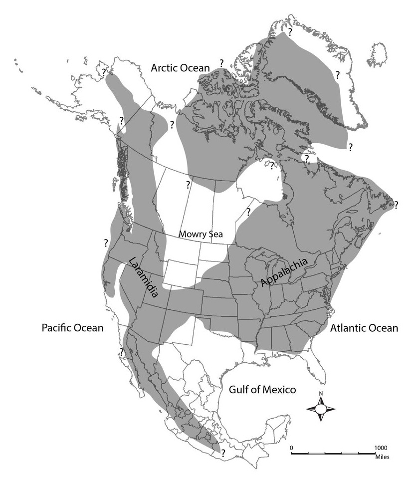
Map of North America during Neogastroplites cornutus biostratigraphic zone of the early Cenomanian Stage, middle Cretaceous Period, 99 MYA. Slattery, Joshua S.; Cobban, William A.; McKinney, Kevin C.; Harries, Peter J.; Sandness, Ashley L. (2013). “Early Cretaceous to Paleocene Paleogeography of the Western Interior Seaway: The Interaction of Eustasy and Tectonism”. Wyoming Geological Association, 68th Annual Field Conference (June 2013). Page 38.
The Mowry Sea is known from multiple layers of rock which were deposited during the early to middle parts of the Cretaceous Period. Each of these layers signifies a time when the sea expanded and shrank. By about 100 million years ago, the Mowry Sea had taken on much of the area that the Sundance Sea had previously occupied sixty million years earlier (2). It would not be until the sea broke through the southern boundary of North America, and turning the continent into two large islands, that the Mowry Sea would become re-named as the Western Interior Sea.
The Skull Creek Shale is the lowest level of marine sediment deposit, and therefore constitutes the earliest stages of the creation of the Mowry Sea. It is identifiable by a very dark shale, almost black in color, that stands out from the rest of the sediment layers, and measures about 250 feet thick. There have been very few fossils found within this layer, consisting mostly of brachiopod and pelycopod shells as well as isolated fish bones and teeth (3).
The Newcastle Sandstone, which lies on top of the Skull Creek Shale, is a mixture of sandstone, claystone, and siltstone. Paleontologists hypothesize that this layer represents a time when the Mowry Sea temporarily shrank and the landscape turned into a shallow brackish water estuary, similar to the Mississippi Delta. Fossils found within this layer are more abundant than in the underlying Skull Creek Shale, and consist of the freshwater snail Viviparus and five species of saltwater clams (Corbula, Mactra, Protocardia, Tellina, and Thracia) (4).
The Mowry Shale, which overlies the Newcastle Sandstone, is a dark gray siliceous shale dated to the middle Cretaceous Period (5). This layer can be found in exposed outcrops throughout much of the northern and central Rocky Mountain region (6).
As you can see, much of the geology of the Mowry Sea consists of shale. Shale is formed from clay and silt particles, which remain suspended in the water column for prolonged periods of time until they eventually settle to the bottom. Other rocks within these layers are siltstone and sandstone. So we can assume that the Mowry Sea had very muddy murky water with very poor visibility. The Mowry Sea was also “hypoxic”, which is a fancy way of saying that the water had very little oxygen in it. Modern-day analogies to such an environment would be the Mississippi Delta, the waters of New York Harbor, and the western half of the Long Island Sound (7).
However, in spite of its oxygen-deficient water, the Mowry Sea was not lifeless. Numerous animal fossils have been found within the Mowry Shale. There were at least two species of ammonites named Metengonoceras and Neogastroplites (8). Several species of bony fish have been found here, identifiable mostly through isolated fossil fish scales (9). One of these was Holcolepis, composed of several species, and possibly resembled a modern-day herring in appearance. The species H. obliquus and H. transversus have been found in the Mowry Shale (10).

Remains of Holcolepis lewesiensis, from England. Image from Fishes, by David S. Jordan (New York: Henry Holt and Company, 1907). Public domain image, Wikimedia Commons.
https://commons.wikimedia.org/wiki/File:FMIB_51738_Primitive_Herring-like_fish,_Lolcolepis_lowesiensis_Mantell,_resotred_Family_Elopidae_English_Chalk.jpeg.
Other fish which swam in the Mowry Sea include Apsopelix, Erythrinolepis, Halecodon, Leucichthyops, and Pelecorapis.
Another fish which was much larger and much more formidable was Xiphactinus, an 18 foot long carnivorous fish commonly found within the Western Interior Sea. The specimen found within the Mowry Shale of Wyoming was previously classified as Hypsodon, but this name has some taxonomic baggage attached to it. The genus Hypsodon was named by the Swiss ichthyologist Louis Agassiz in 1837. Then in 1875, Edward D. Cope alleged that the specimens which Agassiz ascribed to the name Hypsodon actually belonged to several different species, and this genus was a biological chimera. Therefore, each of these specimens would have to be given different names. In fact, Arthur S. Woodward stated in 1901 that he did not consider the name Hypsodon a valid name for any fish since the name didn’t apply to any species in particular. In 1915, Theodore Cockerell suggested that Hypsodon was the senior synonym of Pachyrhizodus, which had been named by Frederick Dixon in 1850. This was re-iterated in 1965 by David Bardack who stated that the genus Hypsodon was actually a pachyrhizodid, not an ichthyodectid as Agassiz had stated: “By priority Hypsodon should apply to a pachyrhizodid, for the first specimen mentioned by Agassiz when he described the single species of Hypsodon is the pachyrhizodid that Woodward (1901) named Thrissopater magnus” (11). Due to all of these confusions, specimens which have previously been lumped under Hypsodon have since been reclassified into several new species, including Xiphactinus audax, Xiphactinus mantelli, Ichthyodectes minor, and Gillicus arcuatus, and the name Hypsodon fell out of usage. The species Hypsodon granulosus, whose remains had been found within the Mowry Shale of Wyoming, has been re-assigned as Xiphactinus (12).

Skeleton of Xiphactinus. Photograph by Chip Clark of the Smithsonian Institution (March 8, 2017). Public domain image, Wikimedia Commons.
https://commons.wikimedia.org/wiki/File:Xiphactinus_fossil_SI.jpg.
At least one species of modern shark, Carcharias amonensis, also swam in these waters (13). The genus Carcharias is the same genus as the modern-day Sand Tiger Shark (Carcharias taurus). This shark is distinctive for its ability to gulp air in order to maintain buoyancy (14). However, this habit might have also been helpful if it lived in water with very low levels of dissolved oxygen. Carcharias amonensis existed from the Cenomanian to the Turonian Stages of the Cretaceous Period and its fossils, mostly teeth, have been found in Kansas, South Dakota, Colorado, and Utah (15).

Sand Tiger Shark (Carcharias taurus). Photo by D. Ross Robertson of the Smithsonian Institution (November 11, 2016). Public domain image, Wikimedia Commons.
https://commons.wikimedia.org/wiki/File:Carcharias_taurus_SI.jpg.
Several marine reptiles are also known to have inhabited the Mowry Sea, including the 12 foot polycotylid plesiosaurs Edgarosaurus and Trinacromerum, the 15 foot pliosaur Brachauchenius, the 18 foot long ichthyosaur Platypterygius, and the impressive 35 foot long elasmosaurid plesiosaur Thalassomedon.
At the same time that the Mowry Sea was expanding, the Gulf of Mexico was also increasing in size due to tectonic shift and rising sea levels, moving further and further northwards. Only a narrow land bridge spanning what’s now southern Colorado and northern New Mexico known as the Transcontinental Arch separated these two water bodies from each other and connected the western and eastern halves of the continent. Sometime during the late Cenomanian and early Turonian Stages, both the Mowry Sea and the Gulf of Mexico dramatically grew in size in an event known as the Greenhorn Transgression. The Mowry Sea would merge with the Gulf of Mexico, creating the Western Interior Seaway, and split North America completely in half (16). The exact date when the joining of the northern and southern seas occurred has been subject to a lot of discussion over the decades, with different articles giving different dates as to when it happened. Robinson-Roberts and Kirschbaum (1995) states that the creation of the Western Interior Seaway occurred during the Neogastroplites cornutus biostratigraphic zone at the beginning of the Cenomanian Stage (17). Slattery et al (2013) states that the Mowry Sea and the Gulf of Mexico joined during the Neogastroplites maclearni biostratigraphic horizon (18), and elsewhere in the article during the Neocardioceras juddii biostratigraphic horizon (19). Neogastroplites maclearni was a species of ammonite whose fossil shells are found within the uppermost layer of the Mowry Shale (20). The ammonite Neocardioceras juddii lived during the late Cenomanian around 93 MYA (21). Most recently in 2023, it was stated that the Greenhorn Transgression took place during the late Cenomanian Stage between 94.6-94.0 MYA based upon the dating of zircons found within volcanic sediments (22).

Map of North America during the Neocardioceras juddii biostratigraphic zone of the late Cenomanian Stage, middle Cretaceous Period, 93 MYA. Slattery, Joshua S.; Cobban, William A.; McKinney, Kevin C.; Harries, Peter J.; Sandness, Ashley L. (2013). “Early Cretaceous to Paleocene Paleogeography of the Western Interior Seaway: The Interaction of Eustasy and Tectonism”. Wyoming Geological Association, 68th Annual Field Conference (June 2013). Page 40.
I truly enjoy writing my articles and drawing my art, but it’s increasingly clear that I can’t keep this up without your gracious financial assistance. Kindly check out my pages on Redbubble and Fine Art America if you want to purchase merch of my artwork. Consider buying my ancient Roman history books Four Days in September: The Battle of Teutoburg and The Great Illyrian Revolt if you’re interested in ancient or military history. Also, please become a patron on my Patreon page so that I can afford to purchase the art supplies and research materials that I need to keep posting art and articles onto this website. Professional art supplies are pricey, and many research articles are “pay to read”, and some academic journals are rather expensive. Patreon donations are just $1 per month – that’s it. If everyone gave just $1 per month, it would go a long way to purchase the stuff that I need to keep my blog “Dinosaurs and Barbarians” running.
Source citations:
- J. A. Jeletzky (1971). “Marine Cretaceous biotic provinces and paleogeography of western and Arctic Canada: Illustrated by a detailed study of ammonites”. Geological Survey of Canada, Paper 70-22, (January 27, 1971). Pages v., 42-49.
- J. D. Stewart and Marjorie Hakel (2006), “Ichthyofauna of the Mowry Shale (Early Cenomanian) of Wyoming”. In New Mexico Museum of Natural History and Science Bulletin 35. Late Cretaceous Vertebrates from the Western Interior. Spencer G. Lucas and Robert M. Sullivan, eds. Albuquerque: New Mexico Museum of Natural History and Science, 2006. Page 161.
- M. H. Bergendahl, R. E. Davis, and G. A. Izett (1960). “Geology and Mineral Deposits of the Carlisle Quadrangle, Crook County, Wyoming”. U. S. Department of the Interior Geological Survey Bulletin 1082-I: Geology and Mineral Deposits of the St. Regis-Superior Area, Mineral County, Montana. Washington: United States Government Printing Office, 1960. Pages 647-648.
- M. H. Bergendahl, R. E. Davis, and G. A. Izett (1960). “Geology and Mineral Deposits of the Carlisle Quadrangle, Crook County, Wyoming”. U. S. Department of the Interior Geological Survey Bulletin 1082-I: Geology and Mineral Deposits of the St. Regis-Superior Area, Mineral County, Montana. Washington: United States Government Printing Office, 1960. Page 650.
- M. H. Bergendahl, R. E. Davis, and G. A. Izett (1960). “Geology and Mineral Deposits of the Carlisle Quadrangle, Crook County, Wyoming”. U. S. Department of the Interior Geological Survey Bulletin 1082-I: Geology and Mineral Deposits of the St. Regis-Superior Area, Mineral County, Montana. Washington: United States Government Printing Office, 1960. Page 651; J. D. Stewart and Marjorie Hakel (2006), “Ichthyofauna of the Mowry Shale (Early Cenomanian) of Wyoming”. In New Mexico Museum of Natural History and Science Bulletin 35. Late Cretaceous Vertebrates from the Western Interior. Spencer G. Lucas and Robert M. Sullivan, eds. Albuquerque: New Mexico Museum of Natural History and Science, 2006. Page 161.
- Douglas A. Sprinkel et al (2012), “Cedar Mountain and Dakota Formations around Dinosaur National Monument: Evidence of the First Incursion of the Cretaceous Western Interior Sea into Utah”. Utah Geological Survey Special Study 143. Page 12.
- J. A. Jeletzky (1971). “Marine Cretaceous biotic provinces and paleogeography of western and Arctic Canada: Illustrated by a detailed study of ammonites”. Geological Survey of Canada, Paper 70-22, (January 27, 1971). Page v.; M. H. Bergendahl, R. E. Davis, and G. A. Izett (1960). “Geology and Mineral Deposits of the Carlisle Quadrangle, Crook County, Wyoming”. U. S. Department of the Interior Geological Survey Bulletin 1082-I: Geology and Mineral Deposits of the St. Regis-Superior Area, Mineral County, Montana. Washington: United States Government Printing Office, 1960. Pages 647-651; J. D. Stewart and Marjorie Hakel (2006), “Ichthyofauna of the Mowry Shale (Early Cenomanian) of Wyoming”. In New Mexico Museum of Natural History and Science Bulletin 35. Late Cretaceous Vertebrates from the Western Interior. Spencer G. Lucas and Robert M. Sullivan, eds. Albuquerque: New Mexico Museum of Natural History and Science, 2006. Page 161; Douglas A. Sprinkel et al (2012), “Cedar Mountain and Dakota Formations around Dinosaur National Monument: Evidence of the First Incursion of the Cretaceous Western Interior Sea into Utah”. Utah Geological Survey Special Study 143. Page 12.
- M. H. Bergendahl, R. E. Davis, and G. A. Izett (1960). “Geology and Mineral Deposits of the Carlisle Quadrangle, Crook County, Wyoming”. U. S. Department of the Interior Geological Survey Bulletin 1082-I: Geology and Mineral Deposits of the St. Regis-Superior Area, Mineral County, Montana. Washington: United States Government Printing Office, 1960. Page 652; William A. Cobban and W. J. Kennedy (1989). “The Ammonite Metengonoceras Hyatt, 1903, from the Mowry Shale (Cretaceous) of Montana and Wyoming”. U.S. Geological Survey Bulletin 1787-L. Washington: United States Government Printing Office, 1989. Pages 1-11.
- J. D. Stewart and Marjorie Hakel (2006), “Ichthyofauna of the Mowry Shale (Early Cenomanian) of Wyoming”. In New Mexico Museum of Natural History and Science Bulletin 35. Late Cretaceous Vertebrates from the Western Interior. Spencer G. Lucas and Robert M. Sullivan, eds. Albuquerque: New Mexico Museum of Natural History and Science, 2006. Page 161.
- T. D. A. Cockerell (1919), “Some American Cretaceous Fish Scales, with Notes on the Classification and Distribution of Cretaceous Fishes”. U. S. Geological Survey. Shorter Contributions to General Geology, professional paper 120. Pages 173-176.
- David Bardack (1965), “Anatomy and evolution of Chirocentrid fishes”. University of Kansas Paleontological Contributions – Vertebrata, article 10. Page 37.
- T. D. A. Cockerell (1919), “Some American Cretaceous Fish Scales, with Notes on the Classification and Distribution of Cretaceous Fishes”. U. S. Geological Survey. Shorter Contributions to General Geology, professional paper 120. Pages 177-179; David Bardack (1965), “Anatomy and evolution of Chirocentrid fishes”. University of Kansas Paleontological Contributions – Vertebrata, article 10. Pages 11, 37, 52, 61-62.
- Douglas A. Sprinkel et al (2012), “Cedar Mountain and Dakota Formations around Dinosaur National Monument: Evidence of the First Incursion of the Cretaceous Western Interior Sea into Utah”. Utah Geological Survey Special Study 143. Page 12.
- The Ultimate Guide: Sharks. The Discovery Channel, 1996.
- Douglas A. Sprinkel et al (2012), “Cedar Mountain and Dakota Formations around Dinosaur National Monument: Evidence of the First Incursion of the Cretaceous Western Interior Sea into Utah”. Utah Geological Survey Special Study 143. Page 12; Cretaceous Atlas of Ancient Life: Western Interior Seaway. “Carcharias amonensis”. https://www.cretaceousatlas.org/species/carcharias-amonensis/.
- Joshua S. Slattery et al (2013). “Early Cretaceous to Paleocene Paleogeography of the Western Interior Seaway: The Interaction of Eustasy and Tectonism”. Wyoming Geological Association, 68th Annual Field Conference (June 2013). Pages 28, 36, 38-39; Khalifa Elderbak et al (2014). “Paleoenvironmental and paleoceanographic changes across the Cenomanian-Turonian Boundary Event (Oceanic Anoxic Event 2) as indicated by foraminiferal assemblages from the eastern margin of the Cretaceous Western Interior Sea”. Palaeogeography, Palaeoclimatology, Palaeoecology, volume 413 (November 1, 2014). Page 29.
- Laura N. Robinson-Roberts and Mark A. Kirschbaum (1995). “Paleogeography of the Late Cretaceous of the Western Interior of Middle North America–Coal Distribution and Sediment Accumulation”. Geological Survey Professional Paper 1561. Washington, DC: United States Government Printing Office, 1995. Pages 5, 15.
- Joshua S. Slattery et al (2013). “Early Cretaceous to Paleocene Paleogeography of the Western Interior Seaway: The Interaction of Eustasy and Tectonism”. Wyoming Geological Association, 68th Annual Field Conference (June 2013). Page 39.
- Joshua S. Slattery et al (2013). “Early Cretaceous to Paleocene Paleogeography of the Western Interior Seaway: The Interaction of Eustasy and Tectonism”. Wyoming Geological Association, 68th Annual Field Conference (June 2013). Page 40.
- John B. Reeside Jr. and William A. Cobban (1960). “Studies of the Mowry Shale (Cretaceous) and Contemporary Formations in the United States and Canada”. Geological Survey Professional Paper 355. Washington, DC: United States Government Printing Office, 1960. Page 27.
- Cretaceous Atlas of Ancient Life: Western Interior Seaway. “Neocardioceras juddii”.
- Ray K. Renaut et al (2023). “Timing of the Greenhorn transgression and OAE2 in Central Utah using CA-TIMS U-Pb zircon dating”. Cretaceous Research, volume 146 (2023).
Bibliography
Articles
Bardack, David (1965). “Anatomy and evolution of Chirocentrid fishes”. University of Kansas Paleontological Contributions – Vertebrata, article 10. Pages 1-88.
https://kuscholarworks.ku.edu/handle/1808/3814.
Bergendahl, M. H.; Davis, R. E.; Izett, G. A. (1960). “Geology and Mineral Deposits of the Carlisle Quadrangle, Crook County, Wyoming”. U. S. Department of the Interior Geological Survey Bulletin 1082-I: Geology and Mineral Deposits of the St. Regis-Superior Area, Mineral County, Montana. Washington: United States Government Printing Office, 1960. Pages 613-706.
https://books.google.com/books?id=N6YPAAAAIAAJ&printsec=frontcover&source=gbs_ge_summary_r&cad=0#v=onepage&q&f=false.
Cobban, William A.; Kennedy, W. J. (1989). “The Ammonite Metengonoceras Hyatt, 1903, from the Mowry Shale (Cretaceous) of Montana and Wyoming”. U.S. Geological Survey Bulletin 1787-L. Washington: United States Government Printing Office, 1989. Pages 1-11.
https://pubs.usgs.gov/bul/1787l/report.pdf.
Cockerell, T. D. A. (1919). “Some American Cretaceous Fish Scales, with Notes on the Classification and Distribution of Cretaceous Fishes”. U. S. Geological Survey. Shorter Contributions to General Geology, professional paper 120. Pages 165-203.
https://pubs.usgs.gov/pp/0120i/report.pdf.
Elderbak, Khalifa; Leckie, R. Mark; Tibert, Neil E. (2014). “Paleoenvironmental and paleoceanographic changes across the Cenomanian-Turonian Boundary Event (Oceanic Anoxic Event 2) as indicated by foraminiferal assemblages from the eastern margin of the Cretaceous Western Interior Sea”. Palaeogeography, Palaeoclimatology, Palaeoecology, volume 413 (November 1, 2014). Pages 29-48.
https://www.researchgate.net/publication/280598264_Paleoceanography_and_paleoenvironmental_changes_of_the_CenomanianTuronian_boundary_interval_94-93_Ma_The_record_of_Oceanic_Anoxic_Event_2_in_the_Western_Interior_Sea.
Jeletzky, J. A. (1971). “Marine Cretaceous biotic provinces and paleogeography of western and Arctic Canada: Illustrated by a detailed study of ammonites”. Geological Survey of Canada, Paper 70-22, (January 27, 1971). Pages 1-92.
https://ftp.maps.canada.ca/pub/nrcan_rncan/publications/STPublications_PublicationsST/100/100663/pa_70_22.pdf.
Reeside Jr., John B.; Cobban, William A. (1960). “Studies of the Mowry Shale (Cretaceous) and Contemporary Formations in the United States and Canada”. Geological Survey Professional Paper 355. Washington, DC: United States Government Printing Office, 1960. Pages 1-126.
https://pubs.usgs.gov/pp/0355/report.pdf.
Renaut, Ray K.; Tucker, Ryan T.; King, M. Ryan; Crowley, James L.; Hyland, Ethan G.; Zanno, Lindsay E. (2023). “Timing of the Greenhorn transgression and OAE2 in Central Utah using CA-TIMS U-Pb zircon dating”. Cretaceous Research, volume 146 (2023).
https://www.sciencedirect.com/science/article/abs/pii/S0195667122003287.
Robinson-Roberts, Laura N.; Kirschbaum, Mark A. (1995). “Paleogeography of the Late Cretaceous of the Western Interior of Middle North America–Coal Distribution and Sediment Accumulation”. Geological Survey Professional Paper 1561. Washington, DC: United States Government Printing Office, 1995. Pages 1-115.
https://pubs.usgs.gov/pp/1561/report.pdf.
Slattery, Joshua S.; Cobban, William A.; McKinney, Kevin C.; Harries, Peter J.; Sandness, Ashley L. (2013). “Early Cretaceous to Paleocene Paleogeography of the Western Interior Seaway: The Interaction of Eustasy and Tectonism”. Wyoming Geological Association, 68th Annual Field Conference (June 2013). Pages 22-60.
https://www.researchgate.net/publication/280641436_EARLY_CRETACEOUS_TO_PALEOCENE_PALEOGEOGRAPHY_OF_THE_WESTERN_INTERIO
Sprinkel, Douglas A.; Madsen, Scott K.; Kirkland, James I.; Waanders, Gerald L.; Hunt, Gary J. (2012). “Cedar Mountain and Dakota Formations around Dinosaur National Monument: Evidence of the First Incursion of the Cretaceous Western Interior Sea into Utah”. Utah Geological Survey Special Study 143. Pages 1-20.
https://ugspub.nr.utah.gov/publications/special_studies/SS-143/SS-143.pdf.
Stewart J. D.; Hakel, Marjorie (2006). “Ichthyofauna of the Mowry Shale (Early Cenomanian) of Wyoming”. In New Mexico Museum of Natural History and Science Bulletin 35. Late Cretaceous Vertebrates from the Western Interior. Spencer G. Lucas and Robert M. Sullivan, eds. Albuquerque: New Mexico Museum of Natural History and Science, 2006. Pages 161-163.
Websites
Cretaceous Atlas of Ancient Life: Western Interior Seaway. “Carcharias amonensis”. https://www.cretaceousatlas.org/species/carcharias-amonensis/.
Cretaceous Atlas of Ancient Life: Western Interior Seaway. “Neocardioceras juddii”.
https://www.cretaceousatlas.org/species/neocardioceras-juddii/.
Videos
The Ultimate Guide: Sharks. The Discovery Channel, 1996.
Categories: Paleontology, Uncategorized

Leave a comment