
Introduction
I subscribe to several ancient Roman history groups on Facebook, and on one of these, a conversation arose regarding the Celtic tribes of Britain. Specifically, there was a lot of focus on one tribe in particular – that of the Setantii or the Setantians. I decided that the best way to add to this online discussion was to do some serious in-depth research on these people.
Almost all of our primary sources concerning the ancient tribes of Britain come from the Romans. However, the Romans themselves wrote very little about them. Often, their name was mentioned, perhaps some scant geographic information, and a few sensationalist factoids designed to entice readers. This is not helpful for modern-day historians and anthropologists.
While in the process of researching the ancient Setantian tribe, I came across information of other tribes that also lived in this area, notably the Volantians and the Carvetians. This article represents the culmination of all of the research that I have done about the ancient inhabitants of Cumbria (northwestern England). I will be addressing them in geographical order from south to north, starting with the Setantians of Lancashire, then the Volantians of Westmoreland and Cumberland, and concluding with the Carvetians of Cumberland. I hope you find it informative and enjoyable.
The Setantians
The first people that I will examine are the Setantians, or Setantii to use the Roman spelling, who inhabited Lancashire in the years prior to the Roman conquest. However, there is very minimal evidence of their geographic location, for their existence is attested in only ONE passing reference in one ancient source.
The Setantians are mentioned, at least in the abstract, by the Greco-Roman geographer Claudius Ptolemy of Alexandria within his book Geography, which was written around 150 AD. In the second chapter of the book, which focuses on the island of Britain, Ptolemy mentions a Portus Setantiorum, meaning “the Port of the Setantii”, located somewhere on Britain’s western coastline. That’s it, that’s all we’ve got. The Setantians are not mentioned anywhere else in any other documents dated before or afterwards (1).
Claudius Ptolemy also makes reference to a “Seteia Estuary”, which is located south of Portus Setantiorum and located rather close to “Gangan Point” in northern Wales. The fact that Claudius Ptolemy uses to separate names to refer to two different locations means that these places are not one and the same. Also, two similar-sounding names are used in relatively the same geographic area may allude to the idea that the Setantians dwelt in this region (2).
Understandably, due to the sparseness of information on this topic, there has been A LOT of academic speculation from the 1700s onwards about who the Setantians were and where exactly this port was located. The exact location of the Portus Setantiorum mentioned by Claudius Ptolemy has vexed many scholars largely due to the fact that Ptolemy never pin-pointed it. All we know for certain is that it was located somewhere between Galloway in the north (known as “Novantian Point” in Roman times in reference to the Novantae tribe which lived there) and the Llŷn Peninsula of northern Wales, known in Roman times as “Caeangani Point” in reference to the Gangani, an Irish tribe which temporarily settled in northwestern Wales). This would place “Port Setant” somewhere on the coastline of Cumbria or Lancashire. Most sources which I have seen state that the Setantians lived in Lancashire, with other tribes dwelling to the north of their territory (3).
What about the name itself? John Whitaker, writing in 1771, and Charles Hardwick, writing in 1857 (and who certainly used Whitaker’s writings as source material), states that the name Setantia is a compound of the words se, tan, and tiu, or perhaps s, is, tan, tiu, meaning “the country of the waters”. (4). So, their name could be a reference to living in close proximity to a river or to the British coast. I’ve also found the occasional claim that the Setantii are named after the Irish mythic hero Setanta or Setantios, which was the original name for the Irish hero Cuchulainn. In “The Celtic Encyclopedia” by Harry Mountain, it states “The Tuath Tabhaira was a clan of the Setantii who settled in Ireland. The Ulster hero Cu Chulainn (BC 2nd-1st c) was of the Tuath Tabhaira clan” (5).
Claudius Ptolemy also mentions a “Seteia Estuary”, and due to the similarity of the spelling to “Setantia”, this has led some scholars to propose that the tribal name means “the people who lived by the Seteia”. Or does it? Yes the two names are spelled similarly, but are they directly related? Possibly but unlikely. In Claudius Ptolemy’s book, Port Setant and the Seteia Estuary are listed as two different places separated from each other by a considerable distance, with the Belisama Estuary lying between the two (6).
There have been numerous proposed locations for both the Seteia Estuary and Port Setant on a modern map. Richard of Cirencester stated that the Seteia River was the same as the Mersey River, and this has been agreed upon by many modern scholars (7), while others like Charles Hardwick states that the Seteia Estuary was the mouth of the River Dee, and that Port Setant was the mouth of the River Wyre (8). James Wallace claims that Portus Setantiorum was modern-day Liverpool (9). Sir John Rhys places Port Setant at the mouth of the Ribble River, which he claims was known in ancient times as the Seteia River, and he goes into a long etymological explanation connecting these two names together (10). John Porter states that the Setantians dwelt along the shore of Moricambe Bay, but this can’t be true because Claudius Ptolemy lists the Moricambe Estuary and Port Setant and two separate places (11).
It was during the middle to late 18th Century that British antiquarians took an interest in the pre-Roman history of Lancashire. One of these men was John Whitaker, a native of the city of Manchester, who, in 1771, published a four-volume series on the history of his hometown. In the first volume, which deals with the ancient history of Manchester, he makes mention of the region’s original Celtic inhabitants, namely the Setantii and the Volantii. These were small and relatively unimportant tribes who were fated to come under the domination of their much larger and more powerful neighbors to the east, the Brigantes of Northumberland, who would, in turn, come under the domination of the Romans.
“Thus settled in the woody region of Lancashire, the colonists received the appropriate name of Setantii, Sistantii, or Sistuntii, as the settlers who took possession of Cumberland and Westmoreland received the appropriate title of Voluntii or Volantii. The name of the former was expressive of their maritime situation. It is compounded of SE, TAN, TIU or S, IS, TAN, TIU, [which] signifies either simply The Country of Water or discriminately The Inferiour (sic) and Southerly Country of Water, and expresses the particular position of Lancashire with respect to the Volantii and the sea. Setantii must have been the original appellation of the original colonists; and Sistantii or Sistuntii must have been afterwards conferred upon them, when new colonists had taken possession of Cumberland and Westmoreland, and when accuracy was obliged to distinguish one from the other. And from the beautiful altar which was discovered at Elenborough in Cumberland, and which is inscribed VOLANTI VIVAS, Elenborough appears to have been originally denominated Volantiu, and was therefore assuredly the original capital of the Volantian towns. But the Sistunii had the towns of Coccui, Bremetonac, Rerigon, Veratin, and our own Mancenion; all acknowledging the first to be, what the name of Coccui or supreme undeniably imports it to have been, the British metropolis of Lancashire. Such was the principality of the Sistuntian Britons, subject to its own capital, and governed by its own regulus” (12)
In summary, John Whitaker claims that the Setantians, whose name means “the people of the country by the water”, inhabited Lancashire, while their Volantian neighbors inhabited Cumbria. The capital of the Setantian tribe was called Coccui, and they also held control of several other settlements, one of which would later become the city of Manchester (13). Yet one wonders how on earth John Whitaker was able to make these claims. Where was his evidence? How on earth could he possibly know which particular town the Setantians held sway over if such information is not mentioned in the historical records? Typical antiquarians, always making claims and suppositions and passing them off as cold hard fact.
According to Vicar Thomas Dunham Whitaker, writing in the early 1800s…
“The Setantii, or rather the Segantii, are placed by that geographer in the mountainous tract usually termed the British Apennine, which divides the island in a longitudinal ridge…Their other boundaries may be conjectured to have been the bay of Moricambe to the North, and the copious aestuary of the Mersey to the South. Thus situated, on an elevated level, along the sources of numerous brooks and of some considerable rivers, their name may be referred to the great characteristic feature of their country, Se cond uii,—the Head of the Waters” (14).
Vicar Thomas Dunham Whitaker has nothing but scorn and contempt for the Setantians, stating “Their attempts to lodge or secure themselves were slight and indolent; in fact, they were careless of self-accommodation, and at a time when whole tribes must have been convoked to rear the massy columns of a temple, they seem to have had no conception of the use of stone in the construction of dwellings, or even for the purposes of fortification” (15). One wonders exactly why he was so disdainful towards them. Evidently, Vicar Thomas thought of the Setantians as primitive savages only one step removed from wild animals who weren’t even as “civilized” as their fellow barbarian neighbors. It’s possible that his reason for his thinking was due to there not being any recognizable Celtic sites which could be positively attributed to this people. Since there was no physical evidence for them, they must not have been a very important or sophisticated people.
I have also found the following reference from William Cathrall dated to 1828, although it is of questionable quality:
“The Setantii, Sistunii, or Sitantii, inhabited Lancashire, and the southern parts of Westmoreland; having Rhigodunum, or Ribchester, and Coccium, or Blackrode, for their chief town…I make Syddynt, an agricultural farm, or tenement, to be the original appellation of the Setantii; from which word the people would be called Syddynti, Syddyntiaid, Syddyntion, Syddyntwyr, and Syddyntwys; importing the dwellers in farms, or those who cultivate the land” (16).
William Cathrall’s etymology of their name as being related to farming is interesting from a philological perspective. However, when it comes to their geopolitical situation, here again is an example of an antiquarian making unsubstantiated claims. Nowhere in the ancient records does it state that either Ribchester of Blackrode were the capital settlements of the Setantian tribe.
According to Charles Henry Timperley…
“The original inhabitants of this part of Britain, according to Ptolemy, seem to have been the Setantii, in one manuscript [the name is written as] Segantii, and in [the account of] the Monk of Cirencester [the name is recorded as] Sistunii, supposed to mean the dwellers among the waters, a tribe of the Brigantes, who inhabited the country between the Rivers Tyne and Humber. It [the land of Lancashire] seems to have been subjugated by Agricola about the year A.D. 79, who soon after established various forts and garrisons” (17)
During the 19th Century, many of John Whitaker’s claims about the Setantians and Volantans came under increased scrutiny and criticism by fellow antiquarians, notably due to his claiming that his opinions and guesses were indisputable facts. One of those who looked at Whitaker’s historical “research”, if I may use that term loosely, with a critical eye was Charles Hardwick, writing in the 1850s, and remarked that Whitaker was taking personal opinions and suppositions and passing them off as fact (18). Finally, we have an antiquarian who recognizes that an opinion and a fact are not the same thing, but even he was not averse to making unsubstantiated claims. He, too, made assertions about the political structure of the Setantian tribe, which went as follows…
“Barbarian men have begun to form communities. Society, though rude and imperfect in many of its relations, has germinated. Petty tribes of partially nude and frightfully disfigured human beings have entered into combinations for mutual defence against combinations ostensibly formed for a similar purpose! Where the Dwr-gwen, the ‘white and beautiful stream,’ [the Darwen] is wedded to the Goch-ui, or the ‘red water’ [the Ribble], nature hath provided sufficient defence against sudden irruption. Rude huts congregate upon this small peninsula, and the stalwart savage chief increases the strength of his fortification, by barricades formed from the limbs of the then luxuriant forest monarch. Ages pass in desultory but savage warfare. One petty tribe yields to another, until the Setantii, or the ‘dwellers by the waters,’ acknowledge a single head. The chief rulers of this tribe assemble at Caer Gochui, or the ‘fortress of the red water.’ Its great natural strength, its central position, and the influence of the most distinguished warrior, secure for it the distinction of the ‘Supreme City.’” (19).
Firstly, there is no evidence whatsoever that Caer Gochui, which stood on the banks of the Ribble River, was the seat of government for the Setantian tribe. Secondly, as to what the “Supreme City” is, named in Welsh as Caer Gochui, one hypothesis is that “Gochui” is a modern rendition of the name “Coccium” mentioned in the Latin texts. John Whitaker states “The Sistunii had the towns of Coccui, Bremetonac, Rerigon, Veratin, and our own Mancenion” (20). Again, there’s no evidence for these claims. Whitaker further states that Coccium served as the tribal capital, and translates its name to “City of Supremacy”, which is markedly different from “Red Water” (21).
A few secondary authors assert that the Setantii were defeated by the Roman legions, commanded by Gnaeus Agricola, within a single campaign season in the year 79 AD. According to Charles Hardwick, to use one example, “The Setantian Britons apparently submitted to Agricola without a serious struggle, in consequence of the previous subjugation of the superior Brigante tribes” (22). However, most secondary authors assert that the Setantians ceased to exist as an independent tribe long before the Romans showed up, and claim that they had been conquered and absorbed by the Brigantes prior to the Roman invasion. According to their relaying of events, the Brigantes, whose lands had previously been limited to Northumbria, expanded westwards and overwhelmed other tribes in their path, subjugating them under their sovereignty. This included the Setantians of Lancashire, who put up a futile resistance, even to the point of allying with their northern Volantian neighbors to oppose the Brigantes, but it was no use. Sometime prior to Emperor Claudius’ invasion of Britain in 43 AD (John Whitaker states that this event occurred at the beginning of the 1st Century AD, but he provides no evidence to back up this claim), the Setantians were conquered and absorbed by their larger and more aggressive Brigante neighbors (23).
The Volantians
To the north of the Setantians of Lancashire dwelt another tribe called the Volantians, who appear to have inhabited the counties of Cumberland and Westmoreland in the years prior to the Roman conquest. Like the Setantians, there is little information about them.
The ancient Romans referred to the northern part of England as “Valentia”. It’s possible that this name is a reference to the Volantian tribe which once called this region their home, but then again, it might be named in reference to something else. According to the 16th Century English writer William Camden, in his work Britain, or, a Chorographicall Description of the most flourishing Kingdomes, England, Scotland, and Ireland, “Valentia seemeth to have been the northerly part of Maxima Caesariensis, which being usurped and held by the Picts and Scots, Theodosius, Generall under Valens the Emperour, recovered out of their hands, and in honour of him named it Valentia which [Ammianus] Marcellinus sheweth more plainely in these words: The Province now recovered, which was fallen into the enemies hands, he restored to the former state, in such sort as by his own procuring it had both a lawful governor, and was also afterwards called Valentia, at the pleasure of the Prince” (24).
John Whitaker, writing in 1771, stated that the Volantii (also spelled Voluntii) were the Setantians’ northern neighbors, and who dwelt in what’s now Cumberland and Westmoreland (25). Charles Hardwick, writing in 1857, stated that the Setantians and Volantians were neighbors, with the Setantians living in Lancashire and the Volantians living directly to the north of them in Cumberland; together, their lands stretched from the Scottish border in the north to the Welsh border in the south (26).
Our evidence for the existence of a tribe called the Volantians is found within the seaside village of Ellenborough in Cumberland. Ellenborough is known for an abundance of Roman inscriptions. One of these was left by a Roman military officer named Gaius Cornelius Peregrinus, a tribune (a battalion commander, equivalent to a major) of an auxiliary cohort from Mauretania Caesariensis (the lands correspond to what’s now eastern Morocco and western Algeria), which was stationed in the vicinity. Another example is of an altar erected by an optio (the second-in-command of a century, equivalent to a lieutenant) which was dedicated to the Celtic war god Belatucadros, indicating that the optio himself was of Celtic nationality. There are many other examples, most of which have been dated to reigns of Antoninus Pius, Commodus, or Caracalla (27).
The area of Ellenborough seems to have been buzzing with military activity. We know of two auxiliary cohort battalions which were posted to the area of the village: the Cohors Prima Dalmatarum “the 1st Cohort of Dalmatians” which was under the command of Publius Postimius Agillanus, and another cohort from what’s now North Africa. The Dalmatians were housed within a fort large enough to accommodate about 500 men, erected atop a hill which guarded the northern side of the mouth of the Ellen River. However, it appears that the fort itself was constructed by detachments from the 2nd Legion Augusta and the 20th Legion Valeria Victrix. An auxiliary cavalry battalion called “the 1st Wing of Hercules” was stationed here during the reign of Emperor Theodosius I (28).
In the year 1599, a sacrificial altar was discovered at Ellenborough. The altar is square-cut, carved from red stone, and measures 5 feet tall. On one side, it bears an inscription dedicated to Gaius Cornelius Peregrinus, which reads as follows (29):
GENIO LOCI
FORTVNAE RED
ROMAE AETERNAE
ET FATO BONO
G CORNELIVS
PEREGRINVS
TRIB COHORT
EX PROVINC
MAVR CAES
DOMVS ET AED
DECVR…
To the Genius of this Place
Good Fortune and Good Fate
To Eternal Rome
Gaius Cornelius Peregrinus
Tribune of the Cohort
Out of the Province
Of Mauretania Caesariensis
House and Buildings
Of the Decurions…
On the rear side, this same altar bears the inscription VOLANTI VIVAS (some sources say it’s VOLANTII VIVAS, but that’s a mistake), which may be translated as either “To the health of Volantus” or “To the health of Volantium” (30). Considering that this altar was meant to invoke the genius, the divine entity who was the spiritual personification of this place, it’s more likely to be a prayer for good luck to be bestowed upon a community rather than to a people. Therefore, it’s probably best to read it as “To the health of Volantium”.
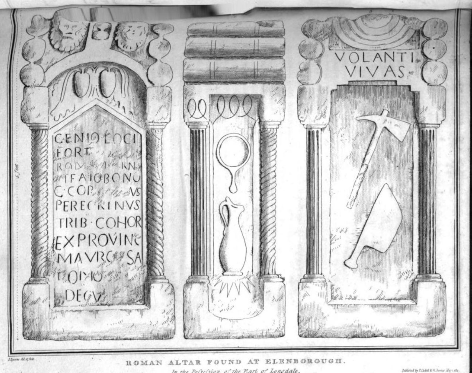
An illustration of the Roman altar found at Ellenborough which bears the inscription VOLANTI VIVAS. Reverend Daniel Lysons and Samuel Lysons, Esq., Magna Britannia, Volume IV: Cumberland. London. T. Cadell, 1816. Image plate between clxxii and clxxiii.
According to a map dated to 1839, a short distance north of the seaside village of Ellenborough is a settlement known as “Volannum”, also known as “Volantium”. (31). John Whitaker stated that Ellenborough may have been the capital settlement of the Volantian tribe (32).
What does the name “Volanti” mean? According to William Cathrall…
“The Volantii, or Voluntii, possessed the northern parts of Westmoreland, and all Cumberland to the wall of Hadrian on the north; having Volanty, or Ellenborough, in the latter, for their capital. In contradistinction to the Setantii, the Volantii were the people of the forests, deriving their name from Gwyllant, a region abounding with coverts, or wilds: and hence they would have the appellation of Gwylleinti, Gwylleintiaid, &c. or Gwyr-y-Gwyllaint, the wood-landers” (33).
There were some doubts as to whether or not the Volanti, Volantii, or Voluntii were even a tribe at all. Reverend Samuel Seyer, writing in 1821, expressed such doubts when he wrote “The Volantii (if there were such a tribe) must have occupied Cumberland and Westmoreland as far as the Wall” (34), but then states that the evidence of their existence is based solely upon one inscription which he feels has been mis-interpreted over the years.
Like the Setantians, the Volantians are commonly believed by secondary scholars to have been conquered and absorbed by the Brigantes prior to the Roman invasion. John Hardwick goes so far as to say that the two peoples had made a treaty of alliance with each other in order to stand against their aggressive Brigante neighbors to the east, but, as with many of his claims, there’s no evidence for this (35). This claim is repeated by Lt.Col. Henry Fishwick, writing in 1878, calling them “confederates”, although he may be speaking in reference to them being members of the Brigante paramountcy (36).
There is the possibility that the Volantians’ domains might have extended outside of northwestern England. The Greco-Roman geographer Claudius Ptolemy mentions another tribe called the Voluntians (notice that their name is spelled with a U instead of an A) living in Ireland during the middle of the 2nd Century AD (37). Are the British “Volantians” and the Irish “Voluntians” actually the same people? This idea has been bounced around since at least the middle 1700s. The anonymous author of a book on the history of County Down in Ireland, published in 1757, stated that the Voluntii of Ireland originally came from “Volantium on the neighboring Coast of Cumberland; which Conjecture arises from an Inscription on a beautiful Altar of red Stone mentioned by Mr. Camden (a) to have been dug up at Elenborough, a town situated at the Mouth of the River Elen, where the first Cohort of the Dalmatians, with their Commander, was garrisoned, whose Name was G. Cornelius Peregrinus, and to whose Honour this People erected it, with these Words, Volantii vivas, may you live at Volantium; a Name taken possibly from the River Elen or Ulen, on which the Town was built. Now the Time that these People passed over into Ireland seems naturally to be ab out the Year of our Lord 76, when the rest of the Brigantes fled hither from Petilius Cerialis, who was the first Roman that invaded this Part of Britain” (38). Over a century later, Thomas Wright stated the Voluntians originally inhabited western Britain but established a population within Ireland (39). This is not outside of the realm of possibility. According to evidence presented by Claudius Ptolemy in his map of ancient Ireland, the Brigantes established a population in eastern Ireland by that time. Therefore, it’s perfectly reasonable that the Volantians/Voluntians of Britain would settle in Ireland, especially if it was to escape from their domineering Brigante overlords (40).
Then again, migration could have gone the other way. Richard of Cirencester claims that the Volantians were originally an Irish tribe who had briefly established a colony in northern England, but soon returned to their homeland (41). This, also, is not outside the realm of possibility. By at least 150 AD, the Gangani of Ireland had established a small enclave in northern Wales (42). In later centuries, waves of Irish immigrants generically known as “Scoti” would settle within northern Britain and eventually give their name to the place. Either way, the possibilities are intriguing.
The Carvetians
The last group of people which will be examined in this article are the Carvetians. Of the three groups discussed here, they are arguably the group that we have the most evidence for. Their name possibly means “the Deer People”, due to the similarity to cervus, the Latin word for “deer”, the Welsh word carw, “deer”, and the Breton word carv, “deer”. Deer were also very prevalent in Celtic art, so the deer was probably their totem animal (43). It has been claimed that ancient Luguvallium, “the city of Luguvalos” (modern-day Carlisle, England) was their capital, but there is little evidence for this (44).
No ancient documents mention any group of people by this name. Our only evidence for their existence comes from inscriptions carved into stone. In the year 1600, a Roman tombstone was discovered at Penrith, Cumberland, located about 18 miles southeast of Carlisle, and 12 miles to the northwest of Appleby. In ancient times, Penrith was known as “Voreda”, and it was the site of a Roman fort, which was built during the time of Emperor Hadrian and remained in use until the 4th Century AD (45).
The tombstone itself no longer survives, but the inscription that it bore was recorded (46). What follows is a copy of the inscription itself, followed by how the inscription would read if the words were written out in full, and followed again by a translation of it into English (47):
D M
FL MARTIO SEN
IN C CARVETIOR
QVESTORIO
VIXIT AN XXXXV
MARTIOLA FILIA ET
HERES PONEN
…CVRAVIT
DIS MANIBUS
FLAVIO MARTIO SENATORI
IN C. CARVETIORVM
QVAESTORIO
VIXIT ANNI XXXXV
MARTIOLA FILIA ET
HERES PONENDUM
CURAVIT
For the Spirit of
Flavius Martius
Of the Senatorial Class
A Quaestor in the ____ of Carvetians
Lived for 45 Years
Martiola is his Daughter and Heir
May he be laid here
And be cared for
There has been some speculation as to what the “C” stands for. One hypothesis was that it stood for “Cohort”, so this Flavius Martius would be a quaestor, a financial officer, assigned to a cohort battalion of Carvetian auxiliaries. Another hypothesis is that the “C” ought to stand for “civitate” or “colonia”, which would make Flavius Martius the treasurer of a settlement inhabited by a people called the Carvetians (48). As we will see, the second option is more plausible.
In 1964, a milestone made of red sandstone was discovered on Frenchfield Farm, which is situated near the village of Carleton, located on the outskirts of Penrith. The inscription on it was short reading, and the end of the inscription bore the letters R P C CAR, which has been taken to represent “Res Publicae Civitas Carvetiorum”. Other inscriptions on the milestone date it to the rebellion of Postumus, who wished to establish an independent “Gallic Empire” from 260-274 AD in the midst of the so-called Third Century Crisis (49).

The Frenchfield Farm milestone, measuring just over 3/4 of a meter tall. Scale bar = 1 meter. From B. J. N. Edwards and D. C. A. Shotter (2005), “Two Roman Milestones from the Penrith Area”. Transactions of the Cumberland & Westmorland Antiquarian & Archaeological Society, volume 5, issue 3 (2005). Page 66.
In 1993, a third milestone was discovered in Langwathby dated to the reign of Emperor Severus Alexander (reign: 222-235 AD). Due to the specific details of the inscription, it can be precisely dated to have been erected in the year 223 AD. Below is a copy of the inscription itself, followed by the abbreviations fully written out, followed by a translation of it in English (50):
IMP · CAES · M · AVR ·
SEV · ALEXANDRO
P · F · AVG · PONT ·
MAX · TR · P · II · COS ·
PCOS · P · P · C · CAR ·
LVG · M · P ·
XVIIII
IMPERATORI CAESARI MARCO AVRELIO
SEVERO ALEXANDRO
PIO FELICI AVGVSTO PONTIFICI
MAXIMO TRIBVNICIA POTESTATE II CONSVLI
PROCONSVLI PATRI PATRIAE CIVITAS CARVETIORVM
LVGVVALIO MILLIA PASSVM
XVIIII
For the Emperor, Caesar Marcus Aurelius Severus Alexander,
The Pious, The Lucky, The August One, Chief Priest,
Holder of the Tribunician Power, Twice Consul of the Senate,
Proconsul, Father of the Fatherland.
The Community of the Carvetians to Luguvalium
Passes Nineteen Miles
It would appear that a tribal community, or civitas, had been established within Cumberland by at least the early 3rd Century AD, and possibly earlier. Why the Romans chose to grant these people a certain degree of autonomy within the Roman province of Britannia is unknown. It has been hypothesized that their establishment might have something to do with the reforms instituted by Emperor Septimius Severus during his stay in Britain from 209-211 AD. Perhaps giving the native Celtic population a certain measure of freedom and elbow room to govern their own affairs within the Roman province might have been leveraged to cultivate support amongst the indigenous population. The Carvetians themselves seem to have been an artificially-created entity, who had been established by the Romans. It’s not known whether the Romans gave them this name, or if they chose it themselves. However, considering the Romans’ track record of creating new “tribes” in the areas that they conquered, such as in Illyricum, I wouldn’t put it past them to concoct a name for them and impose it upon the natives whether they liked it or not (51).

The Langwathby milestone. Scale bar measures centimeters (top) and inches (bottom). From B. J. N. Edwards and D. C. A. Shotter (2005), “Two Roman Milestones from the Penrith Area”. Transactions of the Cumberland & Westmorland Antiquarian & Archaeological Society, volume 5, issue 3 (2005). Page 69.
Athough there are now three inscriptions which make reference to a semi-independent Celtic polity within Cumberland known as “the Carvetians” during the early to middle 200s AD, no mention of them is made afterwards. One possible explanation for this lies in the implication that the Carvetians gave their support to Postumus in his attempt to secede from the Roman Empire and establish Britannia as an independent state. The milestone which was discovered in the 1960s at Frenchfield Farm was set up by the “republic of the civitas of the Carvetians” and was dedicated to the pretender Postumus. They had cast in their lot with a traitor to the empire, and pledging loyalty to an enemy of the state could not go unpunished. No mention of the Carvetians is made after this event. One can only assume that they were completely stripped of their autonomy, and possibly faced even more serious consequences for their actions.
Interestingly, I have occasionally come across the surname “Carveth” in researching the subject of the ancient Carvetii. One of which was John Carveth who served as a member of the Michigan State Senate during the late 1800s. Another instance were two scientific articles written by one H. R. Carveth concerning electrolysis of chromium solutions published in the Journal of Physical Chemistry in 1904. Finally there was the legal case of Mosiman v. Carveth, held on May 21, 1921 in Saskatchewan, Canada concerning a dispute over a land purchase. Despite its extremely close similarity to the Carvetii of Cumbria, I am told that the name “Carveth”, also spelled “Carverth”, is actually of Cornish origin. It derives from caer beth, meaning rather disturbingly “the city of graves”. This implies that the person who originally bore this name lived in close proximity to a cemetery (52).
Conclusion
All evidence suggests that the Setantians and Volantians were small and relatively minor-ranking Celtic tribes which once inhabited northwestern England in the years prior to the Roman invasion of Britain. They had retained their independence for an unknown length of time, but as the neighboring Brigantes of Northumbria grew in power and expanded their domains westwards, the Setantians and Volantians soon came under their domination. As to what happened to them afterwards, one possible outcome was that they were militarily conquered and the Brigantes seized control of their lands by force. However, another explanation (and one which I think is much more likely) is that the Brigantes imposed themselves upon the native population and ruled them as overlords, thus reducing both of these tribes to being subservient vassals of the Brigantes.
As for the Carvetians of Cumberland, they do not seem to be a truly indigenous people who had their own history and culture. Instead, their creation seems to have been purely artificial, created and constructed by the Roman government as away to grant favor to some of the local population, by lumping them together, assigning a name to them, and giving them a headquarters to base themselves in. This appears to have taken place sometime during the early 200s AD, but their quasi-independence didn’t last. They ended up placing their bets on the wrong horse when they backed a rebellious usurper during the Third Century Crisis, a decision which ultimately led to the loss of whatever independence that they had managed to achieve.
Source citations
- Claudius Ptolemy, Geography, book 2, chapter 2.
- Claudius Ptolemy, Geography, book 2, chapter 2.
- Claudius Ptolemy, Geography, book 2, chapter 2.
- John Whitaker, The History of Manchester in Four Books, Volume 1. 1771. Pages 7-8; Charles Hardwick, History of the Borough of Preston and its Environs in the County of Lancaster. Preston: Worthington & Co., 1857. Page 3; Michael Nevell, Tameside Before 1066. Tameside Metropolitan Borough Council, 1992. Page 57.
- Harry Mountain, The Celtic Encyclopedia, Volume 1. UPublish.com, 1998. Page 221.
- Claudius Ptolemy, Geography, book 2, chapter 2.
- Thomas West and William Close, The Antiquities of Furness, New Edition. Elverston: George Ashburner, 1805. Page 3.
- Charles Hardwick, History of the Borough of Preston and its Environs in the County of Lancaster. Preston: Worthington & Co., 1857. Page 36.
- James Wallace, A General and Descriptive History of the Ancient and Present State of the Town of Liverpool, Second Edition. Liverpool: Crane and Jones, 1797. Page 38.
- Sir John Rhys, Celtic Folklore: Welsh and Manx, Volume 1. Oxford: Clarendon Press, 1901. Page 387-388.
- John Porter, History of the Fylde of Lancashire. Fleetwood and Blackpool: W. Porter and Sons, 1876. Page 3.
- John Whitaker, The History of Manchester in Four Books, Volume 1. 1771. Pages 7-8.
- John Whitaker, The History of Manchester in Four Books, Volume 1. 1771. Pages 7-8.
- Thomas Dunham Whitaker, An History of the Original Parish of Whalley, and Honor of Clitheroe, in the Counties of Lancaster and York, Third Edition. London: Nichols, Son, and Bentley, 1818. Page 1.
- Thomas Dunham Whitaker, An History of the Original parish of Whalley, and Honor of Clitheroe, in the Counties of Lancaster and York, Third Edition. London: Nichols, Son, and Bentley, 1818. Page 499.
- William Cathrall, The History of North Wales, Volume 1. 1828. Page 27.
- Charles Henry Timperley, Annals of Manchester; Biographical, Historical, Ecclesiastical, and Commercial, from the Earliest Period to the Close of the Year 1839. Manchester: Bancks and Co., 1839. Pages 3-4.
- Charles Hardwick, History of the Borough of Preston and its Environs in the County of Lancaster. Preston: Worthington & Co., 1857. Page 3.
- Charles Hardwick, History of the Borough of Preston and its Environs in the County of Lancaster. Preston: Worthington & Co., 1857. Page 511.
- John Whitaker, The History of Manchester in Four Books, Volume 1. 1771. Pages 7-8.
- Charles Hardwick, History of the Borough of Preston and its Environs in the County of Lancaster. Preston: Worthington & Co., 1857. Page 37.
- Charles Hardwick, History of the Borough of Preston and its Environs in the County of Lancaster. Preston: Worthington & Co., 1857. Page 36.
- John Whitaker, The History of Manchester in Four Books, Volume 1. 1771. Page 8; Thomas Dunham Whitaker, An History of the Original Parish of Whalley, and Honor of Clitheroe, in the Counties of Lancaster and York, Third Edition. London: Nichols, Son, and Bentley, 1818. Page 1; Charles Henry Timperley, Annals of Manchester; Biographical, Historical, Ecclesiastical, and Commercial, from the Earliest Period to the Close of the Year 1839. Manchester: Bancks and Co., 1839. Pages 3-4; Charles Hardwick, History of the Borough of Preston and its Environs in the County of Lancaster. Preston: Worthington & Co., 1857. Pages 3, 36, 511; Lieutenant-Colonel Henry Fishwick, The History of the Parish of Garstang in the County of Lancaster, Part I. The Chetham Society, 1878. Page 3; William Thompson Watkin, Roman Lancashire. Liverpool: Thomas Draxell, 1883. Page 3.
- William Camden, Britain, or, a Chorographicall Description of the most flourishing Kingdomes, England, Scotland, and Ireland. https://www.visionofbritain.org.uk/travellers/Camden/7.
- John Whitaker, The History of Manchester in Four Books, Volume 1. 1771. Pages 7-8.
- Charles Hardwick, History of the Borough of Preston and its Environs in the County of Lancaster. Preston: Worthington & Co., 1857. Pages 3, 511.
- Old Cumbria Gazetter. “Map of the Lake District, published in A Description of Scenery in the Lake District, by William Ford, published by Charles Thurnham, London, 1839. https://www.lakesguides.co.uk/html/lgaz/lk09723.htm.
- George Alexander Cooke, Topographical and Statistical Description of the County of Westmoreland. London: G. Brimmer, 1802. Page 109; James Dugdale, The New British Traveller, Volume 1. London: J. Robins and Co., 1819. Page 587; Old Cumbria Gazetter. “Map of the Lake District, published in A Description of Scenery in the Lake District, by William Ford, published by Charles Thurnham, London, 1839. https://www.lakesguides.co.uk/html/lgaz/lk09723.htm.
- William Hutchinson, The History and Antiquities of Cumberland, Volume II. Carlisle: F. Jollie, 1794. Page 270; George Alexander Cooke, Topographical and Statistical Description of the County of Westmoreland. London: G. Brimmer, 1802. Page 109.
- John Whitaker, The History of Manchester in Four Books, Volume 1. 1771. Pages 7-8; George Alexander Cooke, Topographical and Statistical Description of the County of Westmoreland. London: G. Brimmer, 1802. Page 109; Old Cumbria Gazetter. “Map of the Lake District, published in A Description of Scenery in the Lake District, by William Ford, published by Charles Thurnham, London, 1839. https://www.lakesguides.co.uk/html/lgaz/lk09723.htm.
- Old Cumbria Gazetter. “Map of the Lake District, published in A Description of Scenery in the Lake District, by William Ford, published by Charles Thurnham, London, 1839. https://www.lakesguides.co.uk/html/lgaz/lk09723.htm.
- John Whitaker, The History of Manchester in Four Books, Volume 1. 1771. Pages 7-8.
- William Cathrall, The History of North Wales, Volume 1. 1828. Page 27.
- Reverend Samuel Seyer, Memoirs Historical and Topographical of Bristol and its Neighborhood, Volume I. Bristol: John Mathew Gutch, 1821. Page 46.
- John Whitaker, The History of Manchester in Four Books, Volume 1. 1771. Page 8.
- Lieutenant-Colonel Henry Fishwick, The History of the Parish of Garstang in the County of Lancaster, Part I. The Chetham Society, 1878. Page 3.
- Claudius Ptolemy, Geography, book 2, chapter 1.
- The Antient (sic) and Present State of the County of Down. Dublin: William Williamson, 1757. Page 2.
- Thomas Wright, The Celt, the Roman, and the Saxon: A History of the Early Inhabitants of Britain, Down to the Conversion of the Anglo-Saxons to Christianity, Third Edition. London: Trübner & Co., 1875. Page 64.
- Claudius Ptolemy, Geography, book 2, chapter 1.
- Thomas Dunham Whitaker, An History of the Original Parish of Whalley, and Honor of Clitheroe, in the Counties of Lancaster and York, Third Edition. London: Nichols, Son, and Bentley, 1818. Page 1.
- Claudius Ptolemy, Geography, book 2, chapter 2.
- Bernard Sergent (1991), “Ethnozoonymes Indo-Europeens”. Dialogues d’Histoire Ancienne, volume 17, issue 2. Page 11; Christopher A. Snyder, The Britons. Malden: Blackwell Publishing, 2003. Page 203; Robin Melrose, Religion in Britain from the Megaliths to Arthur: An Archaeological and Mythological Exploration. Jefferson: McFarland and Company, Inc., 2016. Page 147.
- Dáithi Ó Hógáin, The Celts: A History. Woodbridge: Boydell Press, 2002. Page 181; Robin Melrose, Religion in Britain from the Megaliths to Arthur: An Archaeological and Mythological Exploration. Jefferson: McFarland and Company, Inc., 2016. Page 147; B. J. N. Edwards and D. C. A. Shotter (2005), “Two Roman Milestones from the Penrith Area”. Transactions of the Cumberland & Westmorland Antiquarian & Archaeological Society, volume 5, issue 3 (2005). Page 70.
- Visit Cumbria. “Plumpton – Voreda Roman Fort”. https://www.visitcumbria.com/pen/plumpton-voreda/.
- Roman Britain. “Carvetii”. http://www.roman-britain.co.uk/tribes/carvetii/.
- John Horsley, Britannia Romana: The Roman Antiquities of Britain. London: John Osborn and Thomas Longman, 1732. Page 273.
- John Horsley, Britannia Romana: The Roman Antiquities of Britain. London: John Osborn and Thomas Longman, 1732. Page 273.
- Roman Britain. “Carvetii”. http://www.roman-britain.co.uk/tribes/carvetii/; B. J. N. Edwards and D. C. A. Shotter (2005), “Two Roman Milestones from the Penrith Area”. Transactions of the Cumberland & Westmorland Antiquarian & Archaeological Society, volume 5, issue 3 (2005). Page 65.
- B. J. N. Edwards and D. C. A. Shotter (2005), “Two Roman Milestones from the Penrith Area”. Transactions of the Cumberland & Westmorland Antiquarian & Archaeological Society, volume 5, issue 3 (2005). Pages 65, 67-68.
- B. J. N. Edwards and D. C. A. Shotter (2005), “Two Roman Milestones from the Penrith Area”. Transactions of the Cumberland & Westmorland Antiquarian & Archaeological Society, volume 5, issue 3 (2005). Page 69.
- Reverend John Bannister, A Glossary of Cornish Names. London: Williams and Norgate, 1871. Page 27; House of Names. “Carveth History, Family Crest & Coats of Arms”. https://www.houseofnames.com/carveth-family-crest; Forebears. “Carveth Surname Definition”. https://forebears.io/surnames/carveth.
Bibliography
Books
- Bannister, Reverend John. A Glossary of Cornish Names. London: Williams and Norgate, 1871.
- Camden, William. Britain, or, a Chorographicall Description of the most flourishing Kingdomes, England, Scotland, and Ireland. https://www.visionofbritain.org.uk/travellers/Camden/7.
- Cathrall, William. The History of North Wales, Volume 1. Manchester: J. Gleave and Sons, 1828.
- Cooke, George Alexander. Topographical and Statistical Description of the County of Westmoreland. London: G. Brimmer, 1802.
- Dugdale, James. The New British Traveller, Volume 1. London: J. Robins and Co., 1819.
- Fishwick, Lieutenant-Colonel Henry. The History of the Parish of Garstang in the County of Lancaster, Part I. The Chetham Society, 1878.
- Hardwick, Charles. History of the Borough of Preston and its Environs in the County of Lancaster. Preston: Worthington & Co., 1857.
- Horsley, John. Britannia Romana: The Roman Antiquities of Britain. London: John Osborn and Thomas Longman, 1732.
- Hutchinson, William. The History and Antiquities of Cumberland, Volume II. Carlisle: F. Jollie, 1794.
- Lysons, Reverend Daniel; Lysons, Esq., Samuel. Magna Britannia, Volume IV: Cumberland. London. T. Cadell, 1816.
- Mountain, Harry. The Celtic Encyclopedia, Volume 1. UPublish.com, 1998.
- Nevell, Michael. Tameside Before 1066. Tameside Metropolitan Borough Council, 1992.
- Ó Hógáin, Dáithi. The Celts: A History. Woodbridge: Boydell Press, 2002.
- Porter, John. History of the Fylde of Lancashire. Fleetwood and Blackpool: W. Porter and Sons, 1876.
- Rhys, Sir John. Celtic Folklore: Welsh and Manx, Volume 1. Oxford: Clarendon Press, 1901.
- Seyer, Reverend Samuel. Memoirs Historical and Topographical of Bristol and its Neighborhood, Volume I. Bristol: John Mathew Gutch, 1821.
- Snyder, Christopher A. The Britons. Malden: Blackwell Publishing, 2003.
- Timperley, Charles Henry. Annals of Manchester; Biographical, Historical, Ecclesiastical, and Commercial, from the Earliest Period to the Close of the Year 1839. Manchester: Bancks and Co., 1839.
- Watkin, William Thompson. Roman Lancashire. Liverpool: Thomas Draxell, 1883.
- West, Thomas; Close, William. The Antiquities of Furness, New Edition. Elverston: George Ashburner, 1805.
- Whitaker, John. The History of Manchester in Four Books, Volume 1. 1771.
- Whitaker, Thomas Dunham. An History of the Original Parish of Whalley, and Honor of Clitheroe, in the Counties of Lancaster and York, Third Edition. London: Nichols, Son, and Bentley, 1818.
- Wright, Thomas. The Celt, the Roman, and the Saxon: A History of the Early Inhabitants of Britain, Down to the Conversion of the Anglo-Saxons to Christianity, Third Edition. London: Trübner & Co., 1875.
Articles
- Edwards, B. J. N.; Shotter, D. C. A. (2005), “Two Roman Milestones from the Penrith Area”. Transactions of the Cumberland & Westmorland Antiquarian & Archaeological Society, volume 5, issue 3 (2005). Pages 65-78. https://archaeologydataservice.ac.uk/archiveDS/archiveDownload?t=arch-2055-1/dissemination/pdf/Article_Level_Pdf/tcwaas/003/2005/vol5/tcwaas_003_2005_vol5_0007.pdf.
- Sergent, Bernard (1991). “Ethnozoonymes Indo-Europeens”. Dialogues d’Histoire Ancienne, volume 17, issue 2 (1991). Pages 9-55. https://www.persee.fr/doc/dha_0755-7256_1991_num_17_2_1932.
Websites
- Forebears. “Carveth Surname Definition”. https://forebears.io/surnames/carveth.
- House of Names. “Carveth History, Family Crest & Coats of Arms”. https://www.houseofnames.com/carveth-family-crest.
- Lacus Curtius. Claudius Ptolemy, Geography, book 2, chapters 1-2. https://penelope.uchicago.edu/Thayer/e/gazetteer/periods/roman/_texts/ptolemy/home.html.
- Old Cumbria Gazetter. “Map of the Lake District, published in A Description of Scenery in the Lake District, by William Ford, published by Charles Thurnham, London, 1839. https://www.lakesguides.co.uk/html/lgaz/lk09723.htm.
- Roman Britain. “Carvetii”. http://www.roman-britain.co.uk/tribes/carvetii/.
- Visit Cumbria. “Plumpton – Voreda Roman Fort”. https://www.visitcumbria.com/pen/plumpton-voreda/.
Categories: History, Uncategorized

Leave a comment