

Martello Tower #74, located in Seaford, England. Public domain image, Wikimedia Commons. https://commons.wikimedia.org/wiki/File:Martello_Tower,_Seaford.JPG.
Introduction
General George S. Patton once said “Fixed fortifications are monuments to man’s stupidity”. That was certainly true in the 1940s with aerial bombardment and long-range heavy artillery which could reduce targets to ash and rubble from ten miles away. However, those unfortunate soldiers who were tasked with assaulting fortified positions, such as the Americans at Monte Cassino and Omaha Beach, as well as the US Marines who fought at “the Citadel” in Hue during the Tet Offensive of 1968, can well-attest the difficulties in trying to capture such a position, and usually suffered heavy losses in the process. Fixed fortifications are meant to impede an enemy’s advance, not to defeat or destroy them. The position itself may fall after a heavy attack, but the effort of seizing such a position is so time consuming and so costly in men’s lives that the effort is deemed not worthwhile.
In the age of black powder warfare, fixed fortifications such as these were indeed a serious threat. One such type of fortification was the so-called “Martello tower”. These are evocative of early 19th Century military architecture, and are typically associated with Britain’s coastal defense during the Napoleonic Wars. However, less well-known is that the United States of America also built several Martello towers along the eastern coast from New Hampshire to Louisiana. However, they were very few in number, and the majority of them never saw action.
What is a “Martello tower”?
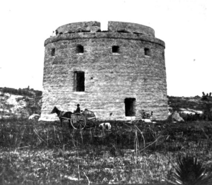
The Martello tower gains its name from the round tower built at Mortella Point (yes, the name is spelled differently) on the Mediterranean island of Corsica. However, this was just one of a multitude of coastal fortifications which were constructed by the native Corsicans and their Genoese rulers since the 1500s to guard against the Barbary pirates. These were referred to, unsurprisingly, as “Genoese towers”. They were round, short (typically measuring 40-50 feet tall, although some could be taller), and had thick walls to protect against cannonfire; sturdiness rather than height was their strength. They commonly had two or three stories, and were large enough to house a platoon-sized garrison of 20-30 men. There was only one entrance elevated off the ground, accessible by a removeable wooden ladder. What made these towers unique was that they had flat roofs which supported one or more large cannons which were mounted on a traverse, enabling the gun to be turned in all directions like a revolving tank turret to bombard any threat from any angle. Below, the walls were perforated here and there with loopholes for firing muskets, swivel guns, or small artillery pieces (Fitzgerald 1883, page 17; The Historical Marker Database. “Walbach Tower”; “Martello Towers – Coastal Defences of the Napoleonic Wars, Aldeburgh, Suffolk”).
Corsica had been ruled by the Italian principality of Genoa since 1284. Then in 1755, the Corsicans revolted against Genoese rule and declared themselves to be an independent republic, led by Pasquale Paoli. The Genoese were driven off, but Corsica’s independence would be short-lived. Genoa agreed to transfer ownership of the island to France as a way to pay off its debts to the French government. The French subsequently invaded Corsica in 1767, and within two years, the rebels were defeated and the whole island was under French control. However, Corsica’s population was both historically and culturally more Italian than French, and French ownership of the island didn’t sit well with many of the people (Caird 1899, pages 23-26, 123-179; The Annual Register 1780, pages 284-285).
With France in upheaval following the French Revolution and the Reign of Terror, and with the recently-established French Republic at war with the British and Austrians, the Corsicans saw an opportunity to make a second stab at independence. In 1794, the Corsican resistance leader Pasquale Paoli requested help from the British to drive the French from the island. The British invaded Corsica that same year; ostensibly, their pretext was to aid the Corsican separatists, but they also had an eye on establishing a foothold on the island to give them a base of operations within the northwestern Mediterranean Sea (“Martello Towers – Coastal Defences of the Napoleonic Wars, Aldeburgh, Suffolk”).
In 1794, the Royal Navy directed its attention towards one of these Genoese towers which guarded the island’s perimeter. It stood upon Mortella (meaning “myrtle”) Point, which lay upon the northwestern part of Mortella Bay, and as such it was referred to as the Torra di Mortella, or Mortella Tower. This tower was armed with two 18-pounder cannons pointing towards the sea and one 6-pounder pointing towards the landward side. On February 7, 1794, HMS Juno (a 32-gun frigate) and HMS Fortitude (a 74-gun “ship-of-the-line” battleship) bombarded this fortified tower for two and a half hours, but the prolonged attack was unable to induce the garrison inside to surrender. In fact, the return firing from tower’s two 18-pounders caused extensive damage to HMS Fortitude during the back-and-forth cannonade. Both British warships withdrew, and it was decided that a landward attack might have better success. The British redcoats who had been landed elsewhere on the shore in January took possession of an eminence which overlooked the tower and brought up some cannons to bombard it. The bombardment from this height lasted for two days until the tower’s garrison gave themselves up. Inside, the British found a garrison of 33 men – none of them had been killed and just two had been wounded, although mortally (The London Gazette – March 11, 1794, pages 221-223; Shore 1915, pages 296-303).
In 1796, the British abandoned Corsica, and the island once again came under French rule. Prior to their departure, the British blew up the Torra di Mortella to make sure that the French couldn’t use it to fire upon their ships ever again. In the report of the action, Lord St. Vincent wrote that the “Martello Tower” had been destroyed. He had mistakenly mis-spelled the name, but that spelling stuck from then onwards (Shore 1915, page 300).
The British were very impressed with how this small tower had been able to withstand such a heavy attack. As a result, the British copied this design and decided to build their own along the coasts of Britain and Ireland to guard against invasion by Napoleonic France. Due to the Royal Navy’s experience in the fighting for the Torra di Mortella, the British referred to all of their towers not as “Genoese towers”, as they had been called since the 1500s, but instead as “Martello towers”. (Shore 1915, pages 298-302; The Historical Marker Database. “Walbach Tower”).
The justification for such defenses was well-founded. The French Navy was the second-largest in the world and was a worthy opponent to the might of His Majesty’s Royal Navy. On December 16, 1796, the French dispatched a fleet of fifteen battleships, ten frigates, and seven transports carrying 15,000 soldiers and 29 cannons bound towards the coast of Ireland. However, the weather was very stormy the whole way, resulting in some ships being blown off course and others crashing into each other. One ship, a 74-gun battleship called the Seduisant, sank after striking a rock shortly after leaving port, resulting in over four-fifths of her crew drowning. Only half of the ships managed to come within sight of the Irish coast on December 23 – the rest of the fleet was God-knows-where. On December 25, the expedition’s commander decided to turn back for France without landing any of the troops. The return voyage was just as foul (Maxwell 1871, pages 28-32). In 1797, a strike force of 1,400 French troops actually landed on British soil in southwestern Wales – this raid was crushed within two days (Rowlands 1892, pages 1-234). Most famously in 1798, over 4,000 French troops landed in County Mayo, Ireland in support of an Irish uprising against British rule – this, too, failed (Maxwell 1871, pages 220-245). By 1803, Napoleon was collecting a massive force for the purpose of invading southern England and seizing control of London. “Old Boney” proclaimed that he needed to be master of the English Channel for only six hours in order for his planned invasion to be successful (“Martello Towers – Coastal Defences of the Napoleonic Wars, Aldeburgh, Suffolk”). To prevent this from happening, the British built over a hundred Martello towers along the shores of England, Wales, Scotland, and Ireland (The Historical Marker Database. “Walbach Tower”).
Not only were such towers erected within the lands of the United Kingdom, but also elsewhere within the British Empire. Other nations got on the Martello tower bandwagon, too. At the same time that the British were building Martello towers along the British and Irish coasts, the Austro-Hungarian Empire erected several of these towers along the Adriatic coast and along the shore of the Danube River. These were referred to as “Maximilian towers” (Shore 1915, page 302).
The United States also began to build Martello towers during the early 1800s to guard against attacks by the British. However, these fortifications were few in number, they were of varying appearance, and they were not always made using the best construction methods. Below is a complete list of all of the Martello towers which had been built within the United States.
New Castle, New Hampshire
The city of Portsmouth, New Hampshire was already under the protective guns of Fort Constitution, which was built on the eastern side of New Castle Island, which guarded Portsmouth Harbor. However, when British warships began attacking New England’s costal settlements during the War of 1812, it was decided to augment Portsmouth’s coastal defense. In the Summer of 1814, Capt. Jean Baptiste de Barth, Baron de Walbach, a French aristocrat who had fled his native soil during Robespierre’s Reign of Terror, and who now served as the commander of the Portsmouth town militia, led his men as well as the townsfolk in constructing a Martello tower atop a ridge called either “Jordan’s Rock” or “Jourdan’s Rocks” on New Castle Island. This tower was christened “Walbach’s Tower” in honor of the man who oversaw its construction. Its brick walls measured 20 feet tall and 58 feet in diameter. A massive 32-pounder cannon proudly crowned its roof, while within the tower itself, three small 4-pounders fired through wall embrasures. Local legend states that the construction was completed within just one night. This is certainly untrue, but what is true is that the construction was done very, very quickly (Hazlett 1915, page 545; Clements 2011, page 196; The Historical Marker Database. “Walbach Tower”).
Unfortunately, as I frequently tell my students, rushed work is often sloppy work, and this tower was no exception. Not only was the structure itself rather architecturally unsound, but the materials which it was made of were not of the best quality. The mortar which was used to cement the bricks together was made of locally-collected beach sand, which was full of salt and led to the structure corroding. By the late 1800s, the tower had fallen into ruins, and its condition deteriorated even further during the 20th Century. Today, only the stump of this tower remains, in the shadow of a large concrete bunker built during World War II (The Historical Marker Database. “Walbach Tower”).
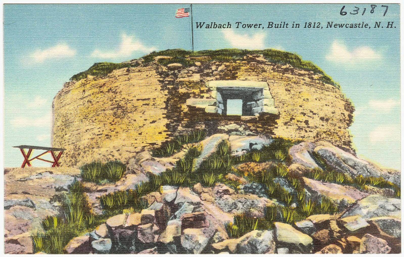
Postcard dated to 1930-1945 showing the ruins of the Walbach Tower. Public domain image, Wikimedia Commons. https://commons.wikimedia.org/wiki/File:Walback_Tower,built_in_1812,_Newcastle,_N.H(63187).jpg.
New Haven, Connecticut
The site of Black Rock, on the eastern side of New Haven Harbor, had been used during the American Revolution for a cannon battery named “Fort Black Rock” to bombard British ships. During the early 1800s, it was decided to strengthen this position further. In 1807, a Martello tower of sorts was built here and christened “Fort Nathan Hale”. Unlike other Martello towers which were round, this one was oval in shape. The fortification was made of cut stone masonry, and its walls measured 50 feet long, 37 feet wide, and just 12 feet high. Upon the fort’s roof were four cannons of unknown caliber mounted en barbette. The tower was already in a ruined state by the beginning of the American Civil War, and it was demolished shortly afterwards to make room for another fortification (Clements 2011, page 198; “Fort Nathan Hale, New Haven”).
In 1921, Congress deeded the site to the State of Connecticut, who afterwards turned it over to the City of New Haven, whereupon it was transformed it into a public park. In 1967, an initiative was made by the private charity “Fort Nathan Hale Restoration Projects, Inc.” to preserve and restore the fortifications which had been built here. Thanks to their efforts, Fort Nathan Hale was registered as a “landmark and historic site” by the US Department of the Interior in 1970, and six years afterwards, the site was officially dedicated. It is now a 20-acre park with reconstructions of the fortifications that had been built there in the past (“Fort Nathan Hale, New Haven”; “Fort Nathan Hale home page”; “About Fort Nathan Hale”).
New York City, New York
In the Summer of 1814, the people of New York City hastily erected several fortifications within Brooklyn and the northern half of Manhattan to guard against an attack by the British during the War of 1812. Construction began in July 1814 on fortifications in Brooklyn and guarding the approach to Hell Gate. When the British fleet stationed in the Long Island Sound bombarded Stonington, Connecticut on August 10, it was believed that the expected British assault against New York City would come soon, and so the building work was hastened. Construction began on a third fortification at McGown’s Pass (in what’s now the northeastern corner of Central Park) which was named “Fort Clinton” in honor of New York City’s mayor DeWitt Clinton. A redoubt was erected at Benson’s Point, near the intersection of 106th Street and 3rd Avenue, where a NYCHA housing project stands today. A wooden tower was built between 113th and 114th Streets and 9th and 10th Avenues – the site is now entirely occupied by Mount Sinai Hospital. Another wooden tower was built on the southern side of 121st Street approximately 110 yards east of 10th Avenue, just a stone’s throw away from Columbia University. A stone tower was built on the south side of 123rd Street and fifty-four yards east of 10th Avenue – a playground and park stand there today. Another fortification named “Fort Laight” stood on the site of the “International House” on Claremont Avenue, in the shadow of Grant’s Tomb (“Central Park in the War of 1812-1815”, pages 421-423).
Of these forts, the most notable was a stone tower which was constructed in what’s now the northwest corner of Central Park. This fortification was known in some 19th Century accounts as “Blockhouse No. 1” or just simply as “the Old Stone Tower”. It was described as standing fourteen yard south of 109th Street and seven yards west of 7th Avenue. The fort measured 34 feet square at the base, and the slightly sloped walls measured 19 feet tall. Two small windows in each face allowed the soldiers inside to shoot their muskets out of. However, the main weapon of the fort was a single heavy artillery piece standing on the blockhouse’s flat roof, which could be traversed in all directions. The flat roof was surrounded by a parapet wall measuring 5 feet high. (“Central Park in the War of 1812-1815”, page 423).
The description of the fort’s rooftop cannon is intriguing and bears similarity to the Martello towers used elsewhere. Indeed, the following was said of it: “A gun mounted to fire over a parapet instead of through an embrasure is called ‘en barbette’. The principle of these towers was the same as that of the picturesque Martello towers which one sees in Kingston and Quebec, Canada. The Martello towers, while round instead of square, and more ingeniously constructed than the towers on Harlem Heights, mounted a single heavy piece each, en barbette, on an elevated terrace, just as the latter were designed to do. The Harlem Heights towers were within supporting distance of each other, and near enough for the interchange of grapeshot” (“Central Park in the War of 1812-1815”, pages 423-424).
The account of the various fortifications within NYC concludes with the statement that Gen. Joseph G. Swift, Chief of Engineers, wrote that none of these forts had cannons mounted on them yet when the militia was dismissed in December 1814, when New York City was no longer to be under the threat of an enemy attack (“Central Park in the War of 1812-1815”, page 424).
The ruins of this fortification are still standing in northwestern Central Park today. Known as “the Blockhouse”, it stands right smack in the center of the park’s North Woods.
Charleston, South Carolina
Charleston was a major port-city within the American South, and as such it was a prime target for attack. The city was well fortified, but it still fell to the British during the Revolution after an intense siege.
During the early 1800s, it was decided that the city’s defenses needed to be augmented even further. Sometime between 1821 and 1830, a Martello tower was built on James Island at the entrance to Charleston Harbor, directly across from Fort Johnson. This tower measured 38 feet tall, 52 feet in diameter, and had walls 10 feet thick. It was constructed of stone and had an overhanging parapet. Unlike other Martello towers, this one did not possess a central pillar to support the roof, but instead had a series of radiating wooden beams like bicycle spokes. This tower originally possessed a wooden roof, but it degraded very quickly in the hot humid climate of the South Carolina coast (Sutcliffe 1973, pages 152-153; Clements 2011, page 196).
In February 1833, extensive repairs needed to be made, and a recommendation was made to have the wooden roof removed and replaced with stone as soon as possible. Due to a lack of available stone, parts of the fort’s walls were repurposed to serve as the roof, which resulted in the fort’s height being dropped down by eight feet. Over this was a canvas tent-like covering, likely to protect the soldiers stationed on the roof from the sun and rain. Four cannons were mounted on the roof en barbette, with each being able to traverse at a 90 degree angle (Sutcliffe 1973, pages 152-153).
In 1859, a fire broke out and the tower was partially destroyed. By 1864, all of the tower except for its base had fallen. (Clements 2011, page 198; “The History of Fort Johnson”).
Tybee Island, Georgia
Tybee Island stands at the mouth of the Savannah River, and guards the seaward approach to the city of Savannah, Georgia. During the American Revolutionary War, Savannah had fallen to the British with remarkable ease. In the evening of December 23, 1778, the inhabitants of Tybee Island observed the British invasion fleet making its approach towards the mouth of the Savannah River. At dawn on December 29, 3,000 redcoats landed on the banks of the river, and marched directly towards the city. The British easily smashed the American troops who had formed up in front of the city to prevent its capture, and that very evening, Savannah was taken (Chappell 1905, pages 131-144).
With war again declared against the British in 1812, and with the threat that Savannah would once again come under attack, it was decided that the harbor’s defenses needed to be strengthened. A Martello tower was built on Tybee Island in 1814-1815. This tower measured 50 feet tall and had walls 10 feet thick. The roof was supported by a hollow brick column like the towers built in Halifax, Nova Scotia. There was an overhanging gallery of wooden hoardings projecting outwards from the parapet, resembling the tower of a medieval castle. The Tybee Island tower originally had just one raised door, but at some point between 1815-1861, a second door was added at ground level. During the American Civil War, it was manned by a Confederate garrison until it was captured by Union forces early in the war. After the war, the tower was abandoned and fell into ruin. The tower was incorporated into the defenses of Fort Screven during the end of the 19th Century, but was afterwards demolished (Clement 2011, pages 196-198).

The Tybee Island Martello tower, photographed by Henry P. Moore in either 1862 or 1863. It is shown with its Union garrison. Getty Museum Collection. https://www.getty.edu/art/collection/object/1045NS#full-artwork-details.
Ruins of the Martello tower on Tybee Island, Georgia, photographed in the late 1800s. US National Archives, Records of the Office of Chief of Engineers, Record Group 77, Fortification Map File, Draw 68, Sheet 30.
Key West, Florida
During the 1820s, it was recommended that the island of Key West, Florida ought to have defensive fortifications built on it. Eventually, a stronghold christened “Fort Zachary Taylor” was built on the island, beginning in 1845 and completed after a multitude of delays in 1861, just in time for the beginning of the Civil War. During the building of this fort, Capt. George Dutton, who was overseeing the fort’s construction, proposed that five Martello towers also ought to be built on the island as a way to augment the fort’s defenses. His recommendation was dismissed (Clements 2011, pages 203-205).
Fort Zachary Taylor quickly fell to the Union forces the year it was finished being built and remained in Union hands throughout the rest of the war. In 1861, the federal government reconsidered the suggestion to build several towers on the island, but they reduced the requested number from five to just two as a means to better defend the landward approaches to Ft. Zachary Taylor. These towers, which were named “Tower 1” and “Tower 2”, were planned as having a base 56 feet square, with walls measuring 36 feet high with two rows of musket loopholes and machicolations on the upper part of each face. The walls facing the sea measured 8 feet, 4 inches thick, while the walls facing the land measured 5 feet, 4 inches thick. Around the tower would be a defensive ditch, and around this was a “counterscarp” gallery and a double-decker casemate battery. Access to the tower was provided by a drawbridge across the ditch connecting the top of the counterscarp gallery to a door on the first floor. The tower’s roof was held up with a central hollow brick pillar, within which was a cast-iron spiral staircase which provided access to all floors as well as the roof. Each of the floors was reinforced with cast-iron girders and a vaulted roof. The intended armament was to be four 100-pounder Parrott rifled guns, while the two-tiered casemate was to be armed with fourteen 10-inch Rodman smoothbore guns (Clements 2011, page 205).
Construction wasn’t yet complete when work was halted in 1866, and no cannons of any kind were mounted on either of the two towers. From the 1870s onwards, Tower 1, now re-named “West Martello Tower” was used as target practice for the gunners at Ft. Zachary Taylor and was partially demolished. Meanwhile, Tower 2, now “East Martello Tower” was used by the US Army for training and accommodation until 1950, when it was handed over to the Key West Art and Historical Society and it was transformed into a museum (Clements 2011, page 205).
Lake Borgne, Louisiana
The famed “Battle of New Orleans” in the War of 1812 (which actually took place at Chalmette, but that’s a quibble for another day) made some Louisianans concerned about the safety of their city against enemy attack. Therefore, it was proposed that a defensive tower should be built on the western end of Lake Borgne at Bayou Dupree. Plans were made in 1821, but it wasn’t regarded as a high priority, so construction didn’t begin until 1829.The work was completed the following year at a cost of $16,677.00 – that would be $549,840.69 in the year 2023. The hexagonal brick-and-masonry tower was three stories tall, and its walls measured 30 feet tall and were 6 feet thick at the base. There were musket loopholes on the ground floor, and six gun embrasures on the upper floors. (Clements 2011, page 198; CPI Inflation Calculator).
In the years following its construction, the tower suffered from repeated damage from floods and hurricanes, and so it was decided in 1847 to remove the top 3rd floor and to cover the remainder with a conical roof of slate tiles. This work was carried out by Lt. Pierre Gustav Toutant Beauregard, who would later become a famous Confederate general during the American Civil War (Clements 2011, page 198).
An 1851 report stated that the tower housed a garrison of 10 men in peacetime, which would be increased to 36 men in wartime. The fort was armed with four 24-pounder cannons, two 8-inch heavy howitzers, and one 10-inch mortar (Clements 2011, pages 198-199). “Tower Dupree”, as it was called, was garrisoned during the American Civil War, but it was abandoned when the war ended. The derelict tower was eventually used as a fishing lodge until it was destroyed by Hurricane Katrina in 2005 (Clements 2011, page 199).
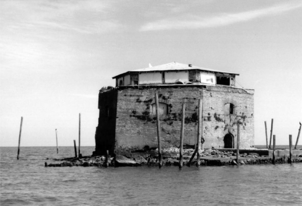
“Tower Dupree” on Lake Borgne, Louisiana, photographed prior to its destruction in 2005 by Hurricane Katrina. Photograph by Dale Manuel. Clements, Bill. Martello Towers Worldwide. Barnsley: Pen & Sword Books, Ltd., 2011. Page 199.
Conclusion: The Death of the Martello Tower
Martello towers were a product of their time. They were perfectly serviceable for fighting in the early 1800s, but by the American Civil War with advancements in artillery warfare, these mini-forts were rendered obsolete. Most of the Martello towers which were built in America were abandoned and had fallen into ruins during the latter half of the 19th Century. By the end of the 19th Century, when long-range heavy-caliber rifled cannons appeared on the battlefield, whatever forts which were left were anachronistic relics from a time when men marched into battle with fifes and drums. In the age of the airplane and the machine gun, such fixed fortifications were, to paraphrase General Patton’s words, nothing more than monuments to a bygone era.
Bibliography
Books
The Annual Register, or a View of the History, Politics, and Literature, for the year 1768, Third Edition. London: J. Dodsley, 1780.
Caird, L. H. The History of Corsica. London: T. Fisher Unwin, 1899.
Chappell, Joseph Harris. Georgia History Stories. New York: Silver, Burdett, and Company, 1905.
Clements, Bill. Martello Towers Worldwide. Barnsley: Pen & Sword Books, Ltd., 2011.
Fitzgerald, Percy. Kings and Queens of an Hour: Records of Love, Romance, Oddity, and Aventure, Volume I. London: Tinsley Brothers, 1883.
Hazlett, Charles A. History of Rockingham County, New Hampshire. Chicago: Richmond-Arnold Publishing Company, 1915.
Maxwell, W. H. History of the Irish Rebellion in 1798, 9th Edition. London: Bell and Daldy, 1871.
Rowlands, Reverend Daniel. The Fishguard Invasion by the French in 1797. London: T. Fisher Unwin, 1892.
Sutcliffe, Sheila. Martello Towers. Cranbury: Fairleigh Dickinson University Press, 1973.
Articles
“Central Park in the War of 1812-1815”. Documents of the Assembly of the State of New York, 134th Session, 1911, volume XXIX, no. 55-58. Albany: J. B. Lyon Company, 1911. Pages 421-428.
CT Monuments. “Fort Nathan Hale, New Haven”. http://ctmonuments.net/2010/08/fort-nathan-hale-new-haven/. Accessed on May 15, 2023.
The London Gazette – March 11, 1794, pages 221-223. https://www.thegazette.co.uk/London/issue/13631/page/222.
Shore, Henry N. (1915). “Lord St. Vincent and the Tower”. The United Service Magazine, volume 51 (April-September 1915). Pages 296-303.
Websites
CPI Inflation Calculator. “Value of $1 from 1830 to 2023”. https://www.officialdata.org/us/inflation/1830?amount=1. Accessed on May 15, 2023.
Fort Nathan Hale and Black Rock Fort. “Fort Nathan Hale home page”. http://www.fort-nathan-hale.org/. Accessed on May 15, 2023.
Fort Nathan Hale and Black Rock Fort. “About Fort Nathan Hale”. http://www.fort-nathan-hale.org/about.html. Accessed on May 15, 2023.
South Carolina Department of Natural Resources. “The History of Fort Johnson” (2020). https://www.dnr.sc.gov/marine/mrri/ftjohnson.html. Accessed on May 14, 2023.
The Historical Marker Database. “Walbach Tower”. https://www.hmdb.org/m.asp?m=135300. Accessed on May 13, 2023.
Videos
YouTube. The Ministry for History. “Martello Towers – Coastal Defences of the Napoleonic Wars, Aldeburgh, Suffolk” (October 29, 2022). https://www.youtube.com/watch?v=d4z_CqDeAZU. Accessed on May 13, 2023.
Categories: History, Uncategorized

.jpg)
Was Civil War artillery really so advanced as to render them obsolete? I thought it wasn’t *that* much more advanced than the Napoleonic era artillery, though I’ll have to look that up. I admit to being rather ignorant on ACW.