
Most people who went to elementary school in the United States were given at least a cursory education in this country’s pre-colonial and colonial history. We learned about the so-called “Thirteen Colonies” which were owned by the British from the early 1600s up until the end of the American Revolutionary War in 1783. We may also be familiar with the fact that other European nations such as the Spanish, French, and Dutch also had colonies within North America, even if most of us cannot remember (or perhaps were never even taught) what these colonies were called.
Those of us who may have received a more detailed education on these matters will point out that the Spanish arrived first, and began claiming territories in what is now the southern United States, including Florida and the American Southwest; collectively, their colonial empire was referred to as “New Spain”. The French likewise began establishing colonies within North America, laying claim to Canada, the Ohio River Valley, and the Mississippi River Valley; their colonial empire was known, rather unsurprisingly, as “New France”. You might be surprised to learn that the Scandinavian country of Sweden briefly possessed a colony on North America’s Atlantic seaboard which was known (that’s right, you guessed it) as “New Sweden”, which encompassed what’s now southern Pennsylvania and northern Delaware, until it was taken over by the Dutch in 1655.
Having lived in New York my whole life, I and my classmates were educated to a great degree on New York’s history going back to its pre-colonial days; for us, the 4th Grade was when we largely learned about the history and heritage of our home state. We learned about the major ethnic groups of Native Americans who once inhabited this land (the Iroquois, the Mahicans, and the Lenapé), we learned about Henry Hudson and other explorers, we learned about the arrival of the Dutch in the early 1600s and the establishment of the colony of “New Netherlands”, and we learned about how the Dutch lands were taken over by the British in the late 1600s, turning “New Netherlands” into “New York”.
New Spain, New France, New Netherlands, and New Sweden…but have you ever heard of “New Belgium”? Most people haven’t, I’ll wager. Yet if you were to look at maps of New York from the early 1600s until the early 1700s, you will often see this name writ large over much of northern New York, encompassing all land from Lake Champlain westwards to Lake Ontario. Did the tiny country of Belgium really once lay claim to the Adirondack Mountains in New York’s northern wilderness, or is this the fictional product of a cartographer’s imagination, or are we just mis-reading the evidence?
Before we dive into this, it would be helpful if we knew a little something about Belgium’s history during this time. For many years, Belgium and the Netherlands were owned by Spain. During the Renaissance, a large part of Europe was ruled by one family – the Hapsburgs. They were Austrian by birth, but in time they came to rule over not only Austria, but also Hungary, Germany, southern Italy, Spain, and the Low Countries (Belgium and the Netherlands). With the exploration and colonization of the New World, the Hapsburgs also ruled over the colonial domains of these kingdoms, and as a result, the Hapsburg family became one of the richest families in the entire world. Yet some people did not like being under their thumb, and in 1568, the Dutch revolted against Spanish Hapsburg rule. The Dutch war of independence lasted for thirteen years, and in 1581, Spain agreed to grant the Netherlands its freedom. Seven years later in 1588, the Netherlands changed from a monarchy to a republic. The “Dutch Republic” would last for over 200 years until it was conquered by the French, led by Napoleon Bonaparte, in 1795.
It ought to be noted that Belgium and the Netherlands did not exist as two separate countries until 1830. Prior to this, these two lands had been merged together into one realm: first as a domain under Spanish Hapsburg rule known either as “the Spanish Netherlands” or “the Austrian Netherlands” in reference to the Hapsburgs’ Austrian origins, then as a united republic dominated by the Dutch, then as a conquered territory under the rule of the French, and then as an independent monarchy again under the domination of the Dutch. Quite simply, Belgium didn’t even exist during the 1600s and 1700s. So how is it possible that there could be a Belgian colony of “New Belgium” located in northern New York?
Perhaps we should take a closer look at the maps from this time to get some answers. A map dated to 1635, which is entitled Nova Belgica et Anglia Nova, “New Belgium and New England”, shows the following features (note that the map is drawn sideways, with north pointing towards the right):
- Novae Franciae Pars, “Part of New France”, indicated in the bottom-right corner of the map, is depicted as land north of Maine in what’s now New Brunswick, Canada.
- Niev Engeland, “New England” written in Dutch, is depicted as all land in what’s now Maine, New Hampshire, and eastern Massachusetts.
- Written directly above the name Niev Engeland in very small letters is the Latin name Nova Anglia, “New England”.
- Niev Nederland, “New Netherlands”, takes up the majority of the map’s space, stretching from central Massachusetts throughout Rhode Island, Connecticut, southern New York, and New Jersey, with its boundary marked by the Delaware River.
- Written above the name Niev Nederland in very small letters is the Latin name Novum Belgium, “New Belgium”.
- All land which lies south of the Delaware River is labeled as Virginiae Pars, “Part of Virginia”, which was an English colony.
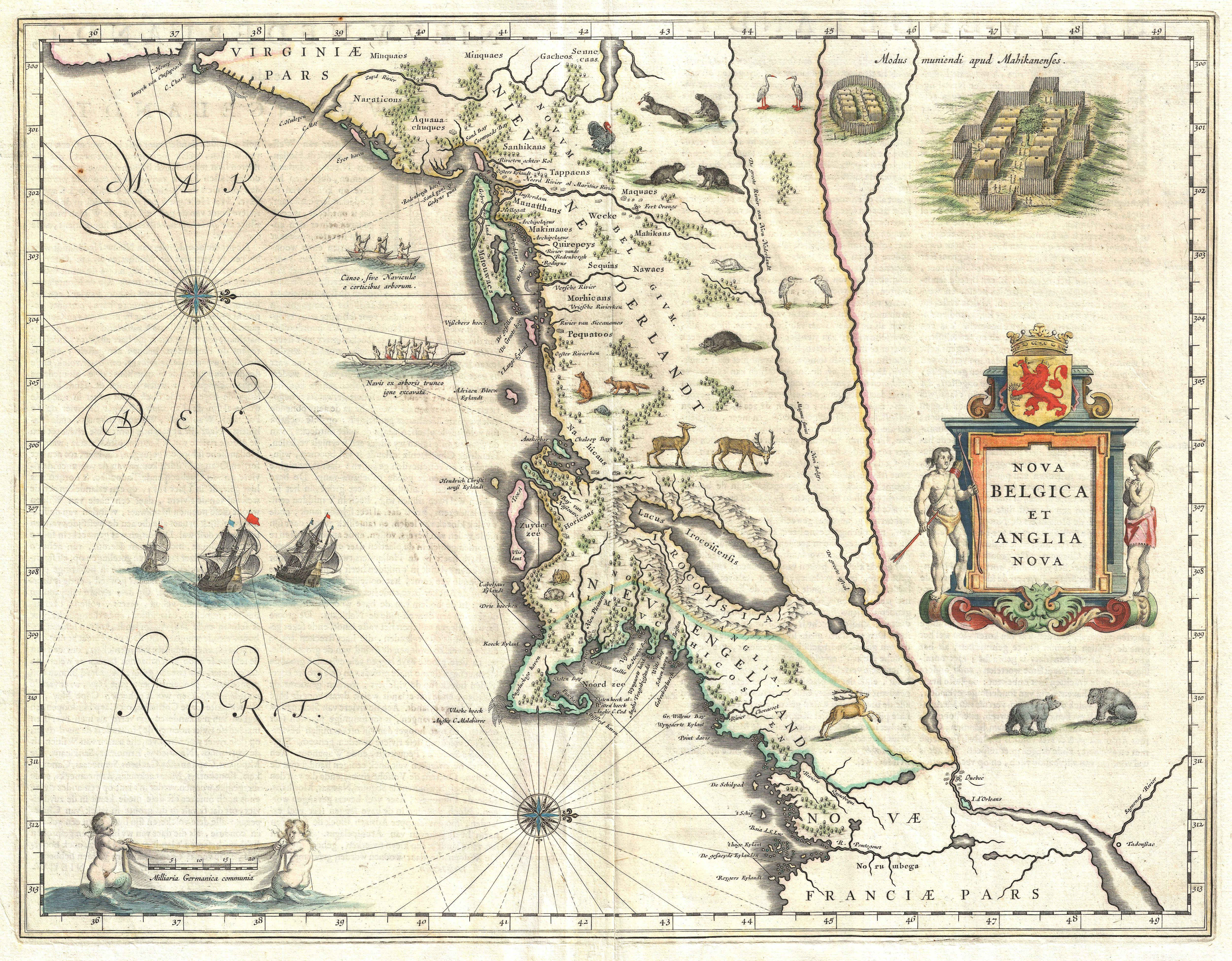
A 1635 map of what’s now the northeastern United States, labeled as Nova Belgica et Anglia Nova, “New Belgium and New England”. Public domain image, Wikimedia Commons. https://commons.wikimedia.org/wiki/File:1635_Blaeu_Map_of_New_England_and_New_York_(1st_depiction_of_Manhattan_as_an_Island)_-_Geographicus_-_NovaBelgicaetAngliaNova-blaeu-1635.jpg.
It’s curious that the name “New Belgium” is shown on this map, and the fact that this name is written above that of New Netherlands would indicate that there was a Belgian colony which lay directly north of New Netherlands. However, this probably isn’t true. More likely, “New Belgium” and “New Netherlands” were simply two different names referring to the same place. Please note that “New England” is labeled on this map with a Latin name written in small letters over a Dutch name written in large letters. Likewise, the Dutch colony appears to be depicted on this map in the same fashion, with a Latin name written in small print on the top and a Dutch name written underneath in much larger letters. Also, take note that the entire map is named Nova Belgica et Anglia Nova, yet its purpose is to provide the viewer with a comparison of the lands owned by the Dutch, not the Belgians, in relation to lands owned by the English. So, it would seem that Nova Belgica, “New Belgium”, was merely a name used by the Classically-educated to refer to the Dutch colony of New Netherlands.
However, this 1635 map is merely one example. As I say to my students, “A statistic of one is useless, a statistic of two is a coincidence, and a statistic of three is evidence”. If we are to proceed with the idea that New Belgium as an independent Belgian colony didn’t actually exist, that it was simply a more flourished name used to refer to the Dutch lands of New Netherlands, then we are going to need more historical examples to examine.
The name Nova Belgica or some variation of it appears on several maps dated throughout the 1600s and into the early 1700s. A map dated to 1647 is entitled Nova Belgica et Anglia Nova, “New Belgium and New England”. Yet if you were to examine the names which are shown on the map, you will quickly notice something very perplexing – there is no New Belgium. True, New France, New England, New Netherlands, and Virginia are clearly labeled, yet there is absolutely no reference whatsoever to New Belgium within northern New York, or indeed anywhere on this map. But the map itself is entitled “New Belgium and New England”. In fact, it would appear that the focus of the map is on Dutch and English territories rather than Belgian and English territories.

A 1647 map entitled Nova Belgica et Anglia Nova, “New Belgium and New England”, which depicts Dutch (not Belgian) and English possessions within North America. Public domain image, Wikimedia Commons. https://commons.wikimedia.org/wiki/File:Novabelgica.jpg.
A map dated to 1685, which is entitled Novi Belgii, Novaeque Angliae, nec non Partis Virginiae Tabula, “A Map of New Belgium, New England, and Part of Virginia”, is another example which we can examine. This map illustrates most of what would become the northeastern United States and even the southernmost parts of Canada. The map clearly shows the name Nova Belgica, “New Belgium”, labeled over what is now northern New York state spread across the Adirondack Mountains. However, written immediately next to it is the name Nieuw, and underneath is Nederlandt, and underneath that is the name Nieuw Jork, “New York” written in Dutch.

A 1685 map entitled Novi Belgii, Novaeque Angliae, nec non Partis Virginiae Tabula, “A Map of New Belgium, New England, and Part of Virginia”, illustrated by Nicolaus Visscher and Peter Schenk. Currently housed within the Library of Congress, Washington, D.C. Public domain image, Wikimedia Commons. https://commons.wikimedia.org/wiki/File:Atlas_Maior_-_Novi_Belgii_-_four_colors.jpg.
Take note that the Nieuw of the name Nieuw Nederlandt is written directly next to the name Nova Belgica. If it was true that New Belgium lay in the north while New Netherlands lay in the south, then you would not expect both names to be written side-by-side; surely one would be written above the other, likely separated by a considerable distance to indicate that these were two separate colonial domains. Yet, we don’t see that – the two names are joined together. It’s almost as if…hmmm…they are two different names (one Latin, and one Dutch) that are being used to refer to the same place.
It’s curious that only one of the names is written in Latin while the names New Netherlands and New York are written in Dutch. Yet if you were to look elsewhere on the map, you will see other examples of Latin and Dutch names being paired together. On the right side of the map in the land that’s shaded red, you will see Nova Anglia paired with Nieuw Engelandt. Clearly, these are two names that are being used to refer to the same place. So, we can infer that Nova Belgica and Nieuw Nederland are no different.
Finally, a map dated to 1716 (which, by the way, is the latest map that I can find which still makes reference to a “New Belgium” somewhere on it) depicts New York being labeled as Novum Belgium in the north spread across the Adirondack Mountains, Nieuw Nederland is located in the center around what’s now Albany, and New Jork (the name is spelled with a J instead of a Y, since the letter J is often pronounced as a Y in several languages) is located in the south around the Catskills and the lower part of the Hudson River. Do these three names represent three separate colonies, or are they simply three different names – one written in Latin, the other in Dutch, and another in English – referring to a single colony? The fact that these three names are lumped together ought to be very telling to the viewer.

A 1716 map entitled Nova Anglia, illustrated by Johann Homann. Public domain image, Wikimedia Commons. https://commons.wikimedia.org/wiki/File:1716_Homann_Map_of_New_England_%22Nova_Anglia%22_-_Geographicus_-_NovaAnglia-homann-1716.jpg.
Another piece of evidence that we should take note of is the distinct lack of identifiable Belgian names on these maps. Quite obviously, the Dutch gave Dutch names to various places which they settled, such as New Amsterdam, Harlem, Flushing, Nieuw Dorp, Fort Orange, and Beverwick. If there really was a large colony which was owned by Belgium in northern New York, then where are names written in Flemish, or names that can be directly referenced to having a Belgian origin? Where is there a “New Brussels”, or a “New Bruges”, or a “New Liege”? There isn’t any. In fact, all of the names which are shown in this region which was apparently claimed by Belgium are definitively native – names like Tadoussac, Onneiochronons, Schanatissa, Iounontego, and Canomakers. These names are, very plainly, not Flemish.
So, in conclusion, I think that it’s safe to say that the name Nova Belgica, or some version of it, did not refer to a separate Belgian colony of “New Belgium” spread throughout much of northern New York. There never really was a Belgian colony of “New Belgium”. Rather, it was a bit of poetic flourish, an alternate Latin name used for the Dutch colony of New Netherlands by Classically-educated 17th and 18th Century cartographers who had studied their Latin and ancient Greek and who customarily labeled their maps using Latin terms and phrases to refer to geographical landmarks and territorial domains rather than words and phrases in their own languages.
Categories: History, Uncategorized

_-_Geographicus_-_NovaBelgicaetAngliaNova-blaeu-1635.jpg)
Reblogged this on Vermont Folk Troth.
Jason R. Abdale: My 1660 Dutch map of the world (Mercator projection) made by Calverstraet clearly labels and shows “Nova Belgium” as a distinct region between New England and Virginia.
True, the Calverstraet map of 1660, entitled “Nova Totius Terrarum Orbis Tabula”, which is housed within the Library of Congress in Washington DC, does have “Nova Belgium” labeled on the map. However, as I pointed out in my article, this is the Latinized name to refer to the Dutch colony of New Netherlands. In fact, all of the names on that map are written in Latin form, because this was the mark of having a Classical education in Latin and ancient Greek.
Correction: “Most” of the names are written in Latin, not all. It’s also interesting to note that the artist retains some Latin linguistic conventions, such as using the letter I instead of J because the letter J didn’t exist in ancient Roman times (such as spelling Japan as “Iapan” and spelling Java as “Iava”), and he occasionally uses the letter V instead of U (such as spelling Guiana as GVIANA, and the Latinized word Oceanus as OCEANVS), and yet he does used the letter U most of the time, so I’m not certain why he didn’t just pick one way or the other.
Very interesting, I never knew about new belgium. Thank you.
This was so interesting. I am buying a jigsaw puzzle that is a different map of New Belgium. Is there a way to share a photo?
I’m not sure if there is a way to post pictures within the comment section. Then again, I don’t think that anybody up to now has ever tried.
https://www.amazingbelgium.be/2016/08/how-belgians-founded-new-york.html
jessé de Forest, one of the future Walloon immigrants moved heaven and earth to obtain the right to emigrate with his own and other Walloon families to the New World. On February 5, 1621, Jessé de Forest sent a petition, written in French, to Sir Dudley Carleton, ambassador of his Majesty the King of England in The Hague. He applied for permission to settle in Virginia with about fifty Walloon, French and Flemish families. Jessé asked to dispose over a territory of eight English miles radius. Known as the Round Robin, this document is now preserved in the British Public Record Office.
I think you are missing something quite important here. “Gallia Belgica” was a Latin geographical term appropriated by geographers in Early Modern Europe to refer to the region around the North Sea covering modern-day Belgium and the Netherlands. At this time, “Belgica” (Belgium) was essentially a Latin translation of the Dutch word “Nederlanden” (literally, Low Countries). Sub-regions within the Low Countries would be known by their local county like Tournaisis or Holland.
It was only very gradually that “Belgica” (Belgium) and “Nederlanden” (Netherlands) terms began to split apart conceptually and begin to attach to different regions. It really only seems to have happened in the 1770s or 1780s.
great post! I think you solved the riddle